Daweishan geodata
Daweishan (Hunan) is a seat of a fourth-order administrative division; located in China in Asia/Shanghai (GMT+8) time zone. In our database, there are 1268 cities with bigger population. Compared to other cities in China, 70% of cities are located further ↑North; 51.4% of cities are located further →East and 51.2% of cities have higher elevation than Daweishan. Note1


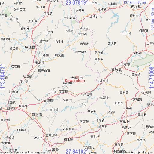
Daweishan GPS coordinates[2]
28° 27' 42.696" North, 114° 0' 28.26" East
| Map corner | latitude | longitude |
|---|---|---|
| Upper-left | 29.07819°, | 113.30473° |
| Center: | 28.46186°, | 114.00785° |
| Lower-right: | 27.84192°, | 114.71098° |
| Map W x H: | 137.5×137.5 km | = 85.4×85.4mi |
| max Lat: | 53.31946° ⇑70% North |
| Daweishan: | 28.46186° |
| min Lat: | ⇓30% South 18.22056° |
| min Long | Daweishan | max Long |
| 75.07348° | 114.00785° | 134.28917° |
| W 48.6%⇐ | ⇒51.4% E |
Elevation
Elevation of Daweishan is 155 m = 509 ft, and this is 329.8 m = 1082 ft below average elevation for this country.
| Max E: |
5622 m = 18445 ft | 51.2% |
| Avg. | 484.8 m = 1591 ft | |
| Daweishan | 155 m = 509 ft | |
Min E: |
-3 m = -10 ft | 48.8% |
See also: China elevation on elevation.city.
Geographical zone
Daweishan is located in North temperate zone (between Tropic of Cancer and the Arctic Circle). Distance of this Northern Tropic circle is 558.7 km =347.2 mi to South.| Distance of | km | miles | from Daweishan |
|---|---|---|---|
| North Pole | 6842.4 | 4251.7 | to North |
| Arctic Circle | 4236.5 | 2632.4 | to North |
| Tropic Cancer | 558.7 | 347.2 | to South |
| Equator | 3164.7 | 1966.5 | to South |


Nearby cities:
15 places around Daweishan: (largest is in red/bold)
• Baisha
7.5 km =4.7 mi,  80°
80°
• Baishui
33 km =20.5 mi,  156°
156°
• Chixing
35.9 km =22.3 mi,  141°
141°
• Gaoqiao
25.3 km =15.7 mi,  50°
50°
• Heshikou
27.1 km =16.8 mi,  169°
169°
• Huangjindong
21.6 km =13.4 mi,  12°
12°
• Huangmao
39.9 km =24.8 mi, 170°
• Longmen
38.9 km =24.2 mi, 6°
• Nanqiao
31.3 km =19.4 mi, 11°
• Paibu
23.7 km =14.7 mi,  97°
97°
• Qiping
29.7 km =18.5 mi,  40°
40°
• Wenquan
34.4 km =21.4 mi, 75°
• Xianyuan
30.5 km =19 mi,  126°
126°
• Yongning
35.7 km =22.2 mi, 78°
• Zhangfang
17.6 km =10.9 mi,  148°
148°
Sources, notices
• [Note1] Compared only with cities in China existing in our database
• [Src1] Map data: © OpenStreetMap contributors (CC-BY-SA)
• [Src2] Other city data from geonames.org with taken over terms of usage.
• [Src3] Geographical zone / Annual Mean Temperature by Robert A. Rohde @ Wikipedia
