Baishi geodata
Baishi (Hunan) is a seat of a fourth-order administrative division; located in China in Asia/Shanghai (GMT+8) time zone. In our database, there are 1268 cities with bigger population. Compared to other cities in China, 57.4% of cities are located further ↑North; 68.7% of cities are located further →East and 86.3% of cities have lower elevation than Baishi. Note1


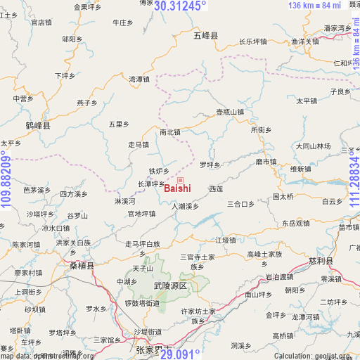
Baishi GPS coordinates[2]
29° 42' 12.888" North, 110° 35' 6.756" East
| Map corner | latitude | longitude |
|---|---|---|
| Upper-left | 30.31245°, | 109.88209° |
| Center: | 29.70358°, | 110.58521° |
| Lower-right: | 29.091°, | 111.28834° |
| Map W x H: | 135.8×135.8 km | = 84.4×84.4mi |
| max Lat: | 53.31946° ⇑57.4% North |
| Baishi: | 29.70358° |
| min Lat: | ⇓42.6% South 18.22056° |
| min Long | Baishi | max Long |
| 75.07348° | 110.58521° | 134.28917° |
| W 31.3%⇐ | ⇒68.7% E |
Elevation
Elevation of Baishi is 1062 m = 3484 ft, and this is 577.2 m = 1894 ft above average elevation for this country.
| Max E: |
5622 m = 18445 ft | 13.7% |
| Baishi | 1062 m 3484 ft | |
| Avg. | 484.8 m = 1591 ft | |
Min E: |
-3 m = -10 ft | 86.3% |
See also: China elevation on elevation.city.
Geographical zone
Baishi is located in North temperate zone (between Tropic of Cancer and the Arctic Circle). Distance of this Northern Tropic circle is 696.8 km =433 mi to South.| Distance of | km | miles | from Baishi |
|---|---|---|---|
| North Pole | 6704.3 | 4165.9 | to North |
| Arctic Circle | 4098.4 | 2546.6 | to North |
| Tropic Cancer | 696.8 | 433 | to South |
| Equator | 3302.7 | 2052.2 | to South |


Nearby cities:
15 places around Baishi: (largest is in red/bold)
• Baiguo
23.6 km =14.7 mi,  328°
328°
• Guandiping
19 km =11.8 mi,  229°
229°
• Linxihe
22.1 km =13.7 mi,  249°
249°
• Louziqiu
27.7 km =17.2 mi, 229°
• Luojiaping
12.4 km =7.7 mi,  62°
62°
• Nanzhen
19 km =11.8 mi,  349°
349°
• Renchaoxi
10.5 km =6.5 mi,  179°
179°
• Sanhekou
24.6 km =15.3 mi,  110°
110°
• Suoziqiu
27.7 km =17.2 mi, 229°
• Xilian
14.1 km =8.8 mi,  101°
101°
• Zhaojiagang
24.7 km =15.3 mi,  158°
158°
• Zhenjiatai
10.7 km =6.6 mi,  263°
263°
• Zhujiatai
8.9 km =5.5 mi,  296°
296°
• Zhuyeping
26 km =16.2 mi,  189°
189°
• Zouma
20.9 km =13 mi,  311°
311°
Sources, notices
• [Note1] Compared only with cities in China existing in our database
• [Src1] Map data: © OpenStreetMap contributors (CC-BY-SA)
• [Src2] Other city data from geonames.org with taken over terms of usage.
• [Src3] Geographical zone / Annual Mean Temperature by Robert A. Rohde @ Wikipedia
