Nanzhen geodata
Nanzhen (Hubei) is a seat of a fourth-order administrative division; located in China in Asia/Shanghai (GMT+8) time zone. In our database, there are 1268 cities with bigger population. Compared to other cities in China, 55.4% of cities are located further ↑North; 68.9% of cities are located further →East and 85.2% of cities have lower elevation than Nanzhen. Note1


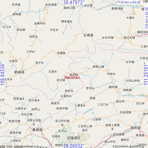
Nanzhen GPS coordinates[2]
29° 52' 18.768" North, 110° 32' 54.528" East
| Map corner | latitude | longitude |
|---|---|---|
| Upper-left | 30.47972°, | 109.84536° |
| Center: | 29.87188°, | 110.54848° |
| Lower-right: | 29.26032°, | 111.25161° |
| Map W x H: | 135.6×135.6 km | = 84.3×84.3mi |
| max Lat: | 53.31946° ⇑55.4% North |
| Nanzhen: | 29.87188° |
| min Lat: | ⇓44.6% South 18.22056° |
| min Long | Nanzhen | max Long |
| 75.07348° | 110.54848° | 134.28917° |
| W 31.1%⇐ | ⇒68.9% E |
Elevation
Elevation of Nanzhen is 995 m = 3264 ft, and this is 510.2 m = 1674 ft above average elevation for this country.
| Max E: |
5622 m = 18445 ft | 14.8% |
| Nanzhen | 995 m 3264 ft | |
| Avg. | 484.8 m = 1591 ft | |
Min E: |
-3 m = -10 ft | 85.2% |
See also: China elevation on elevation.city.
Geographical zone
Nanzhen is located in North temperate zone (between Tropic of Cancer and the Arctic Circle). Distance of this Northern Tropic circle is 715.5 km =444.6 mi to South.| Distance of | km | miles | from Nanzhen |
|---|---|---|---|
| North Pole | 6685.6 | 4154.2 | to North |
| Arctic Circle | 4079.7 | 2535 | to North |
| Tropic Cancer | 715.5 | 444.6 | to South |
| Equator | 3321.4 | 2063.8 | to South |


Nearby cities:
15 places around Nanzhen: (largest is in red/bold)
• Baiguo
9 km =5.6 mi,  278°
278°
• Baishi
19 km =11.8 mi,  169°
169°
• Guandiping
32.9 km =20.4 mi,  199°
199°
• Linxihe
31.6 km =19.6 mi,  212°
212°
• Luojiaping
19.4 km =12.1 mi,  131°
131°
• Nishi
23.2 km =14.4 mi,  72°
72°
• Renchaoxi
29.5 km =18.3 mi, 172°
• Suojie
34.4 km =21.4 mi,  88°
88°
• Wantan
23 km =14.3 mi,  328°
328°
• Wuli
19.8 km =12.3 mi, 277°
• Xilian
27.6 km =17.1 mi,  140°
140°
• Yanzi
33.4 km =20.8 mi,  288°
288°
• Zhenjiatai
21.1 km =13.1 mi, 199°
• Zhujiatai
15.3 km =9.5 mi, 196°
• Zouma
13 km =8.1 mi,  248°
248°
Sources, notices
• [Note1] Compared only with cities in China existing in our database
• [Src1] Map data: © OpenStreetMap contributors (CC-BY-SA)
• [Src2] Other city data from geonames.org with taken over terms of usage.
• [Src3] Geographical zone / Annual Mean Temperature by Robert A. Rohde @ Wikipedia
