Tasha geodata
Tasha (Hunan) is a seat of a fourth-order administrative division; located in China in Asia/Shanghai (GMT+8) time zone. In our database, there are 1268 cities with bigger population. Compared to other cities in China, 64.7% of cities are located further ↑North; 73.5% of cities are located further →East and 76.9% of cities have lower elevation than Tasha. Note1


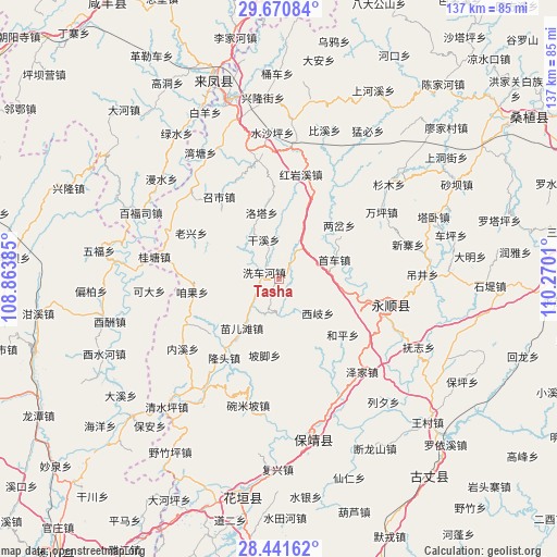
Tasha GPS coordinates[2]
29° 3' 29.016" North, 109° 34' 1.092" East
| Map corner | latitude | longitude |
|---|---|---|
| Upper-left | 29.67084°, | 108.86385° |
| Center: | 29.05806°, | 109.56697° |
| Lower-right: | 28.44162°, | 110.2701° |
| Map W x H: | 136.7×136.7 km | = 84.9×84.9mi |
| max Lat: | 53.31946° ⇑64.7% North |
| Tasha: | 29.05806° |
| min Lat: | ⇓35.3% South 18.22056° |
| min Long | Tasha | max Long |
| 75.07348° | 109.56697° | 134.28917° |
| W 26.5%⇐ | ⇒73.5% E |
Elevation
Elevation of Tasha is 574 m = 1883 ft, and this is 89.2 m = 293 ft above average elevation for this country.
| Max E: |
5622 m = 18445 ft | 23.1% |
| Tasha | 574 m 1883 ft | |
| Avg. | 484.8 m = 1591 ft | |
Min E: |
-3 m = -10 ft | 76.9% |
See also: China elevation on elevation.city.
Geographical zone
Tasha is located in North temperate zone (between Tropic of Cancer and the Arctic Circle). Distance of this Northern Tropic circle is 625 km =388.4 mi to South.| Distance of | km | miles | from Tasha |
|---|---|---|---|
| North Pole | 6776.1 | 4210.5 | to North |
| Arctic Circle | 4170.2 | 2591.2 | to North |
| Tropic Cancer | 625 | 388.4 | to South |
| Equator | 3231 | 2007.6 | to South |


Nearby cities:
15 places around Tasha: (largest is in red/bold)
• Dianfang
9 km =5.6 mi,  178°
178°
• Duishan
18.6 km =11.6 mi,  151°
151°
• Fengxizhai
13.1 km =8.1 mi,  244°
244°
• Jiajiaba
20.2 km =12.6 mi,  298°
298°
• Jiashi
18.7 km =11.6 mi, 239°
• Liangchahe
19.7 km =12.2 mi,  48°
48°
• Luotache
17.3 km =10.7 mi,  345°
345°
• Matizhai
14.1 km =8.8 mi,  25°
25°
• Mengxihu
11.2 km =7 mi,  309°
309°
• Miao’ertan
15.1 km =9.4 mi,  217°
217°
• Pojiao
19 km =11.8 mi,  190°
190°
• Shaoha
19.9 km =12.4 mi,  101°
101°
• Xichehe
3.6 km =2.2 mi,  293°
293°
• Xiqi
12.8 km =8 mi,  131°
131°
• Xishaping
10.1 km =6.3 mi,  338°
338°
Sources, notices
• [Note1] Compared only with cities in China existing in our database
• [Src1] Map data: © OpenStreetMap contributors (CC-BY-SA)
• [Src2] Other city data from geonames.org with taken over terms of usage.
• [Src3] Geographical zone / Annual Mean Temperature by Robert A. Rohde @ Wikipedia
