Xichehe geodata
Xichehe (Hunan) is a seat of a fourth-order administrative division; located in China in Asia/Shanghai (GMT+8) time zone. In our database, there are 1268 cities with bigger population. Compared to other cities in China, 64.6% of cities are located further ↑North; 73.7% of cities are located further →East and 65.4% of cities have lower elevation than Xichehe. Note1


Xichehe GPS coordinates[2]
29° 4' 16.032" North, 109° 31' 59.556" East
| Map corner | latitude | longitude |
|---|---|---|
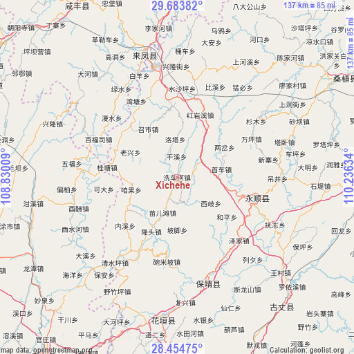
| Upper-left | 29.68382°, | 108.83009° |
| Center: | 29.07112°, | 109.53321° |
| Lower-right: | 28.45475°, | 110.23634° |
| Map W x H: | 136.7×136.7 km | = 84.9×84.9mi |
| max Lat: | 53.31946° ⇑64.6% North |
| Xichehe: | 29.07112° |
| min Lat: | ⇓35.4% South 18.22056° |
| min Long | Xichehe | max Long |
| 75.07348° | 109.53321° | 134.28917° |
| W 26.3%⇐ | ⇒73.7% E |
Elevation
Elevation of Xichehe is 333 m = 1093 ft, and this is 151.8 m = 498 ft below average elevation for this country.
| Max E: |
5622 m = 18445 ft | 34.6% |
| Avg. | 484.8 m = 1591 ft | |
| Xichehe | 333 m = 1093 ft | |
Min E: |
-3 m = -10 ft | 65.4% |
See also: China elevation on elevation.city.
Geographical zone
Xichehe is located in North temperate zone (between Tropic of Cancer and the Arctic Circle). Distance of this Northern Tropic circle is 626.5 km =389.3 mi to South.| Distance of | km | miles | from Xichehe |
|---|---|---|---|
| North Pole | 6774.7 | 4209.6 | to North |
| Arctic Circle | 4168.8 | 2590.4 | to North |
| Tropic Cancer | 626.5 | 389.3 | to South |
| Equator | 3232.4 | 2008.5 | to South |


Nearby cities:
15 places around Xichehe: (largest is in red/bold)
• Dianfang
11 km =6.8 mi,  161°
161°
• Fengxizhai
11.1 km =6.9 mi,  230°
230°
• Jiajiaba
16.6 km =10.3 mi,  299°
299°
• Jiashi
16.9 km =10.5 mi, 229°
• Laoxingchang
20.7 km =12.9 mi, 297°
• Luotache
15.3 km =9.5 mi,  356°
356°
• Matizhai
14.6 km =9.1 mi,  39°
39°
• Mengxihu
7.8 km =4.8 mi,  316°
316°
• Miao’ertan
14.7 km =9.1 mi,  203°
203°
• Pojiao
20.2 km =12.6 mi,  180°
180°
• Tasha
3.6 km =2.2 mi,  113°
113°
• Xiqi
16.3 km =10.1 mi,  127°
127°
• Xishaping
8 km =5 mi, 356°
• Zanguoping
18.6 km =11.6 mi,  254°
254°
• Zhaoshi
21.1 km =13.1 mi,  330°
330°
Sources, notices
• [Note1] Compared only with cities in China existing in our database
• [Src1] Map data: © OpenStreetMap contributors (CC-BY-SA)
• [Src2] Other city data from geonames.org with taken over terms of usage.
• [Src3] Geographical zone / Annual Mean Temperature by Robert A. Rohde @ Wikipedia
