Yanggu’ao geodata
Yanggu’ao (Hunan) is a seat of a fourth-order administrative division; located in China in Asia/Shanghai (GMT+8) time zone. In our database, there are 1268 cities with bigger population. Compared to other cities in China, 76.7% of cities are located further ↑North; 67.2% of cities are located further →East and 68.4% of cities have lower elevation than Yanggu’ao. Note1


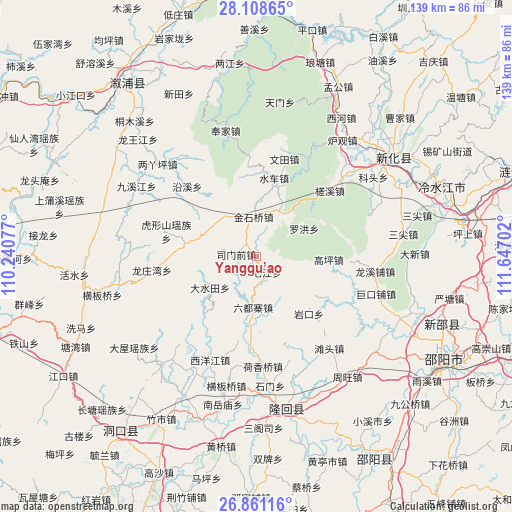
Yanggu’ao GPS coordinates[2]
27° 29' 12.012" North, 110° 56' 38.004" East
| Map corner | latitude | longitude |
|---|---|---|
| Upper-left | 28.10865°, | 110.24077° |
| Center: | 27.48667°, | 110.94389° |
| Lower-right: | 26.86116°, | 111.64702° |
| Map W x H: | 138.7×138.7 km | = 86.2×86.2mi |
| max Lat: | 53.31946° ⇑76.7% North |
| Yanggu’ao: | 27.48667° |
| min Lat: | ⇓23.3% South 18.22056° |
| min Long | Yanggu’ao | max Long |
| 75.07348° | 110.94389° | 134.28917° |
| W 32.8%⇐ | ⇒67.2% E |
Elevation
Elevation of Yanggu’ao is 383 m = 1257 ft, and this is 101.8 m = 334 ft below average elevation for this country.
| Max E: |
5622 m = 18445 ft | 31.6% |
| Avg. | 484.8 m = 1591 ft | |
| Yanggu’ao | 383 m = 1257 ft | |
Min E: |
-3 m = -10 ft | 68.4% |
See also: China elevation on elevation.city.
Geographical zone
Yanggu’ao is located in North temperate zone (between Tropic of Cancer and the Arctic Circle). Distance of this Northern Tropic circle is 450.3 km =279.8 mi to South.| Distance of | km | miles | from Yanggu’ao |
|---|---|---|---|
| North Pole | 6950.8 | 4319 | to North |
| Arctic Circle | 4344.9 | 2699.8 | to North |
| Tropic Cancer | 450.3 | 279.8 | to South |
| Equator | 3056.2 | 1899 | to South |


Nearby cities:
15 places around Yanggu’ao: (largest is in red/bold)
• Dashuitian
15.1 km =9.4 mi,  237°
237°
• Gaoping
19.6 km =12.2 mi,  92°
92°
• Hetian
15.8 km =9.8 mi,  169°
169°
• Huangjinjing
12.2 km =7.6 mi,  334°
334°
• Huxingshan
25.3 km =15.7 mi,  285°
285°
• Jinshiqiao
10.9 km =6.8 mi,  356°
356°
• Liuduzhai
13.4 km =8.3 mi,  183°
183°
• Luohong
15.1 km =9.4 mi,  59°
59°
• Qijiang
5 km =3.1 mi,  145°
145°
• Shuiche
22.9 km =14.2 mi,  13°
13°
• Simenqian
5.7 km =3.5 mi,  270°
270°
• Xiaoshajiang
19.7 km =12.2 mi,  281°
281°
• Xixi
23 km =14.3 mi,  2°
2°
• Yankou
21 km =13 mi,  137°
137°
• Yatian
13.6 km =8.5 mi,  30°
30°
Sources, notices
• [Note1] Compared only with cities in China existing in our database
• [Src1] Map data: © OpenStreetMap contributors (CC-BY-SA)
• [Src2] Other city data from geonames.org with taken over terms of usage.
• [Src3] Geographical zone / Annual Mean Temperature by Robert A. Rohde @ Wikipedia
