Luohong geodata
Luohong (Hunan) is a seat of a fourth-order administrative division; located in China in Asia/Shanghai (GMT+8) time zone. In our database, there are 1268 cities with bigger population. Compared to other cities in China, 76.4% of cities are located further ↑North; 66.8% of cities are located further →East and 74% of cities have lower elevation than Luohong. Note1


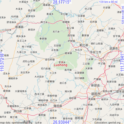
Luohong GPS coordinates[2]
27° 33' 20.016" North, 111° 4' 31.008" East
| Map corner | latitude | longitude |
|---|---|---|
| Upper-left | 28.17715°, | 110.37216° |
| Center: | 27.55556°, | 111.07528° |
| Lower-right: | 26.93044°, | 111.77841° |
| Map W x H: | 138.6×138.6 km | = 86.1×86.1mi |
| max Lat: | 53.31946° ⇑76.4% North |
| Luohong: | 27.55556° |
| min Lat: | ⇓23.6% South 18.22056° |
| min Long | Luohong | max Long |
| 75.07348° | 111.07528° | 134.28917° |
| W 33.2%⇐ | ⇒66.8% E |
Elevation
Elevation of Luohong is 500 m = 1640 ft, and this is 15.2 m = 50 ft above average elevation for this country.
| Max E: |
5622 m = 18445 ft | 26% |
| Luohong | 500 m 1640 ft | |
| Avg. | 484.8 m = 1591 ft | |
Min E: |
-3 m = -10 ft | 74% |
See also: China elevation on elevation.city.
Geographical zone
Luohong is located in North temperate zone (between Tropic of Cancer and the Arctic Circle). Distance of this Northern Tropic circle is 458 km =284.6 mi to South.| Distance of | km | miles | from Luohong |
|---|---|---|---|
| North Pole | 6943.2 | 4314.3 | to North |
| Arctic Circle | 4337.3 | 2695.1 | to North |
| Tropic Cancer | 458 | 284.6 | to South |
| Equator | 3063.9 | 1903.8 | to South |


Nearby cities:
15 places around Luohong: (largest is in red/bold)
• Dashuitian
30.1 km =18.7 mi,  238°
238°
• Gaoping
10.7 km =6.6 mi,  141°
141°
• Hetian
25.3 km =15.7 mi,  203°
203°
• Huangjinjing
18.4 km =11.4 mi,  280°
280°
• Jinshiqiao
14.1 km =8.8 mi, 283°
• Liuduzhai
25.2 km =15.7 mi,  213°
213°
• Qijiang
15.5 km =9.6 mi,  220°
220°
• Shangmei
30.1 km =18.7 mi,  46°
46°
• Shuiche
16.4 km =10.2 mi,  332°
332°
• Simenqian
20.1 km =12.5 mi,  247°
247°
• Xiaoshajiang
32.5 km =20.2 mi,  263°
263°
• Xixi
19.5 km =12.1 mi,  321°
321°
• Yanggu’ao
15.1 km =9.4 mi, 239°
• Yankou
23.1 km =14.4 mi,  176°
176°
• Yatian
7.2 km =4.5 mi,  304°
304°
Sources, notices
• [Note1] Compared only with cities in China existing in our database
• [Src1] Map data: © OpenStreetMap contributors (CC-BY-SA)
• [Src2] Other city data from geonames.org with taken over terms of usage.
• [Src3] Geographical zone / Annual Mean Temperature by Robert A. Rohde @ Wikipedia
