Fengle geodata
Fengle (Heilongjiang) is a seat of a fourth-order administrative division; located in China in Asia/Shanghai (GMT+8) time zone. In our database, there are 1268 cities with bigger population. Compared to other cities in China, 96.6% of cities are located further ↓South; 99.8% of cities are located further ←West and 59.2% of cities have higher elevation than Fengle. Note1


Fengle GPS coordinates[2]
46° 48' 52.488" North, 130° 51' 48.672" East
| Map corner | latitude | longitude |
|---|---|---|
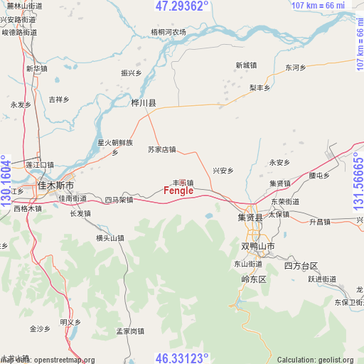
| Upper-left | 47.29362°, | 130.1604° |
| Center: | 46.81458°, | 130.86352° |
| Lower-right: | 46.33123°, | 131.56665° |
| Map W x H: | 107×107 km | = 66.5×66.5mi |
| max Lat: | 53.31946° ⇑3.4% North |
| Fengle: | 46.81458° |
| min Lat: | ⇓96.6% South 18.22056° |
| min Long | Fengle | max Long |
| 75.07348° | 130.86352° | 134.28917° |
| W 99.8%⇐ | ⇒0.2% E |
Elevation
Elevation of Fengle is 103 m = 338 ft, and this is 381.8 m = 1253 ft below average elevation for this country.
| Max E: |
5622 m = 18445 ft | 59.2% |
| Avg. | 484.8 m = 1591 ft | |
| Fengle | 103 m = 338 ft | |
Min E: |
-3 m = -10 ft | 40.8% |
See also: China elevation on elevation.city.
Geographical zone
Fengle is located in North temperate zone (between Tropic of Cancer and the Arctic Circle). Distance of this North polar circle is 2195.9 km =1364.5 mi to North.| Distance of | km | miles | from Fengle |
|---|---|---|---|
| North Pole | 4801.8 | 2983.7 | to North |
| Arctic Circle | 2195.9 | 1364.5 | to North |
| Tropic Cancer | 2599.4 | 1615.2 | to South |
| Equator | 5205.3 | 3234.4 | to South |


Nearby cities:
15 places around Fengle: (largest is in red/bold)
• Changfa
31.5 km =19.6 mi,  253°
253°
• Chuangye
20 km =12.4 mi,  304°
304°
• Fuli
23.4 km =14.5 mi,  116°
116°
• Hengtoushan
26.8 km =16.7 mi,  232°
232°
• Jianguo
24.9 km =15.5 mi,  285°
285°
• Jianguo
35.6 km =22.1 mi,  270°
270°
• Lingdong
34.9 km =21.7 mi,  142°
142°
• Shuangyashan
29.7 km =18.5 mi,  131°
131°
• Simajia
19.4 km =12.1 mi,  255°
255°
• Songjiang
32.9 km =20.4 mi, 273°
• Sujiadian
11.7 km =7.3 mi,  327°
327°
• Taiping
13.9 km =8.6 mi,  244°
244°
• Xinghuo
22.5 km =14 mi, 298°
• Yuelai
25.9 km =16.1 mi, 333°
• Zhenxing
35.4 km =22 mi, 334°
Sources, notices
• [Note1] Compared only with cities in China existing in our database
• [Src1] Map data: © OpenStreetMap contributors (CC-BY-SA)
• [Src2] Other city data from geonames.org with taken over terms of usage.
• [Src3] Geographical zone / Annual Mean Temperature by Robert A. Rohde @ Wikipedia
