Zhenlai geodata
Zhenlai (Jilin) is a seat of a third-order administrative division; located in China in Asia/Shanghai (GMT+8) time zone. With population of 67,760 people, there are 633 cities with bigger population in this country. Compared to other cities in China, 94.8% of cities are located further ↓South; 93% of cities are located further ←West and 54.4% of cities have higher elevation than Zhenlai. Note1


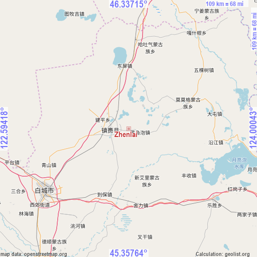
Zhenlai GPS coordinates[2]
45° 50' 58.38" North, 123° 17' 50.28" East
| Map corner | latitude | longitude |
|---|---|---|
| Upper-left | 46.33715°, | 122.59418° |
| Center: | 45.84955°, | 123.2973° |
| Lower-right: | 45.35764°, | 124.00043° |
| Map W x H: | 108.9×108.9 km | = 67.7×67.7mi |
| max Lat: | 53.31946° ⇑5.2% North |
| Zhenlai: | 45.84955° |
| min Lat: | ⇓94.8% South 18.22056° |
| min Long | Zhenlai | max Long |
| 75.07348° | 123.2973° | 134.28917° |
| W 93%⇐ | ⇒7% E |
Elevation
Elevation of Zhenlai is 135 m = 443 ft, and this is 349.8 m = 1148 ft below average elevation for this country.
| Max E: |
5622 m = 18445 ft | 54.4% |
| Avg. | 484.8 m = 1591 ft | |
| Zhenlai | 135 m = 443 ft | |
Min E: |
-3 m = -10 ft | 45.6% |
See also: Zhenlai elevation on elevation.city.
Geographical zone
Zhenlai is located in North temperate zone (between Tropic of Cancer and the Arctic Circle). Distance of this North polar circle is 2303.2 km =1431.1 mi to North.| Distance of | km | miles | from Zhenlai |
|---|---|---|---|
| North Pole | 4909.1 | 3050.4 | to North |
| Arctic Circle | 2303.2 | 1431.1 | to North |
| Tropic Cancer | 2492.1 | 1548.5 | to South |
| Equator | 5098 | 3167.7 | to South |


Nearby cities:
15 places around Zhenlai: (largest is in red/bold)
• Baicheng
45.7 km =28.4 mi,  233°
233°
• Baomin
42.9 km =26.7 mi,  357°
357°
• Deshun
58.6 km =36.4 mi,  214°
214°
• Dongping
26.7 km =16.6 mi, 356°
• Ganq Ger
49.5 km =30.8 mi,  35°
35°
• Haoxin
55.7 km =34.6 mi,  21°
21°
• Hongsheng
53.7 km =33.4 mi,  1°
1°
• Linhai
55.9 km =34.7 mi, 228°
• Mingren
46.8 km =29.1 mi, 232°
• Ningjiang
58.7 km =36.5 mi,  34°
34°
• Pingtai
52.3 km =32.5 mi,  253°
253°
• Qingshan
36 km =22.4 mi, 249°
• Tantu
37.4 km =23.2 mi,  5°
5°
• Tumuji
53.1 km =33 mi,  332°
332°
• Wukeshu
40.4 km =25.1 mi,  52°
52°
Sources, notices
• [Note1] Compared only with cities in China existing in our database
• [Src1] Map data: © OpenStreetMap contributors (CC-BY-SA)
• [Src2] Other city data from geonames.org with taken over terms of usage.
• [Src3] Geographical zone / Annual Mean Temperature by Robert A. Rohde @ Wikipedia
