Baicheng geodata
Baicheng (Jilin) is a seat of a second-order administrative division; located in China in Asia/Shanghai (GMT+8) time zone. With population of 316,970 people, there are 174 cities with bigger population in this country. Compared to other cities in China, 94.5% of cities are located further ↓South; 92.5% of cities are located further ←West and 51.6% of cities have higher elevation than Baicheng. Note1


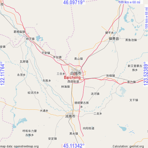
Baicheng GPS coordinates[2]
45° 36' 26.856" North, 122° 49' 14.736" East
| Map corner | latitude | longitude |
|---|---|---|
| Upper-left | 46.09719°, | 122.11764° |
| Center: | 45.60746°, | 122.82076° |
| Lower-right: | 45.11342°, | 123.52389° |
| Map W x H: | 109.4×109.4 km | = 68×68mi |
| max Lat: | 53.31946° ⇑5.5% North |
| Baicheng: | 45.60746° |
| min Lat: | ⇓94.5% South 18.22056° |
| min Long | Baicheng | max Long |
| 75.07348° | 122.82076° | 134.28917° |
| W 92.5%⇐ | ⇒7.5% E |
Elevation
Elevation of Baicheng is 152 m = 499 ft, and this is 332.8 m = 1092 ft below average elevation for this country.
| Max E: |
5622 m = 18445 ft | 51.6% |
| Avg. | 484.8 m = 1591 ft | |
| Baicheng | 152 m = 499 ft | |
Min E: |
-3 m = -10 ft | 48.4% |
See also: Baicheng elevation on elevation.city.
Geographical zone
Baicheng is located in North temperate zone (between Tropic of Cancer and the Arctic Circle). Distance of this North polar circle is 2330.1 km =1447.9 mi to North.| Distance of | km | miles | from Baicheng |
|---|---|---|---|
| North Pole | 4936 | 3067.1 | to North |
| Arctic Circle | 2330.1 | 1447.9 | to North |
| Tropic Cancer | 2465.2 | 1531.8 | to South |
| Equator | 5071.1 | 3151 | to South |


Nearby cities:
15 places around Baicheng: (largest is in red/bold)
• Anding
52 km =32.3 mi,  199°
199°
• Deshun
22 km =13.7 mi,  169°
169°
• Dongping
64.1 km =39.8 mi,  33°
33°
• Guangming
30.6 km =19 mi,  185°
185°
• Heishui
45.3 km =28.1 mi,  180°
180°
• Linhai
11.1 km =6.9 mi,  207°
207°
• Mingren
1.6 km =1 mi, 185°
• Pingtai
18 km =11.2 mi,  312°
312°
• Ping’an
27.4 km =17 mi, 305°
• Qingshan
14.8 km =9.2 mi,  12°
12°
• Shuanggang
56.4 km =35 mi, 171°
• Taodong
21.6 km =13.4 mi,  257°
257°
• Wafang
37.6 km =23.4 mi,  282°
282°
• Xianghai
73.7 km =45.8 mi, 209°
• Zhenlai
45.7 km =28.4 mi,  53°
53°
Sources, notices
• [Note1] Compared only with cities in China existing in our database
• [Src1] Map data: © OpenStreetMap contributors (CC-BY-SA)
• [Src2] Other city data from geonames.org with taken over terms of usage.
• [Src3] Geographical zone / Annual Mean Temperature by Robert A. Rohde @ Wikipedia
