Mingren geodata
Mingren (Jilin) is a seat of a third-order administrative division; located in China in Asia/Shanghai (GMT+8) time zone. In our database, there are 1268 cities with bigger population. Compared to other cities in China, 94.5% of cities are located further ↓South; 92.5% of cities are located further ←West and 51.9% of cities have higher elevation than Mingren. Note1


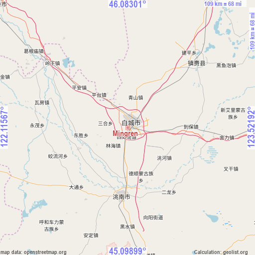
Mingren GPS coordinates[2]
45° 35' 35.376" North, 122° 49' 7.644" East
| Map corner | latitude | longitude |
|---|---|---|
| Upper-left | 46.08301°, | 122.11567° |
| Center: | 45.59316°, | 122.81879° |
| Lower-right: | 45.09899°, | 123.52192° |
| Map W x H: | 109.4×109.4 km | = 68×68mi |
| max Lat: | 53.31946° ⇑5.5% North |
| Mingren: | 45.59316° |
| min Lat: | ⇓94.5% South 18.22056° |
| min Long | Mingren | max Long |
| 75.07348° | 122.81879° | 134.28917° |
| W 92.5%⇐ | ⇒7.5% E |
Elevation
Elevation of Mingren is 150 m = 492 ft, and this is 334.8 m = 1098 ft below average elevation for this country.
| Max E: |
5622 m = 18445 ft | 51.9% |
| Avg. | 484.8 m = 1591 ft | |
| Mingren | 150 m = 492 ft | |
Min E: |
-3 m = -10 ft | 48.1% |
See also: China elevation on elevation.city.
Geographical zone
Mingren is located in North temperate zone (between Tropic of Cancer and the Arctic Circle). Distance of this North polar circle is 2331.7 km =1448.9 mi to North.| Distance of | km | miles | from Mingren |
|---|---|---|---|
| North Pole | 4937.6 | 3068.1 | to North |
| Arctic Circle | 2331.7 | 1448.9 | to North |
| Tropic Cancer | 2463.6 | 1530.8 | to South |
| Equator | 5069.5 | 3150 | to South |


Nearby cities:
15 places around Mingren: (largest is in red/bold)
• Anding
50.4 km =31.3 mi,  199°
199°
• Baicheng
1.6 km =1 mi,  5°
5°
• Deshun
20.4 km =12.7 mi,  167°
167°
• Dongping
65.5 km =40.7 mi,  32°
32°
• Guangming
29 km =18 mi,  185°
185°
• Heishui
43.7 km =27.2 mi,  180°
180°
• Linhai
9.6 km =6 mi,  211°
211°
• Pingtai
19 km =11.8 mi,  316°
316°
• Ping’an
28.2 km =17.5 mi,  308°
308°
• Qingshan
16.4 km =10.2 mi, 11°
• Shuanggang
54.8 km =34.1 mi, 171°
• Taodong
21.1 km =13.1 mi,  261°
261°
• Wafang
37.8 km =23.5 mi,  285°
285°
• Xianghai
72.2 km =44.9 mi, 210°
• Zhenlai
46.8 km =29.1 mi,  52°
52°
Sources, notices
• [Note1] Compared only with cities in China existing in our database
• [Src1] Map data: © OpenStreetMap contributors (CC-BY-SA)
• [Src2] Other city data from geonames.org with taken over terms of usage.
• [Src3] Geographical zone / Annual Mean Temperature by Robert A. Rohde @ Wikipedia
