Qinghe geodata
Qinghe (Heilongjiang) is a seat of a fourth-order administrative division; located in China in Asia/Shanghai (GMT+8) time zone. In our database, there are 1268 cities with bigger population. Compared to other cities in China, 95.3% of cities are located further ↓South; 98.6% of cities are located further ←West and 58.8% of cities have higher elevation than Qinghe. Note1


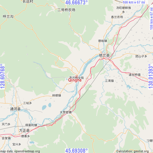
Qinghe GPS coordinates[2]
46° 10' 55.416" North, 129° 18' 38.88" East
| Map corner | latitude | longitude |
|---|---|---|
| Upper-left | 46.66673°, | 128.60768° |
| Center: | 46.18206°, | 129.3108° |
| Lower-right: | 45.69308°, | 130.01393° |
| Map W x H: | 108.3×108.3 km | = 67.3×67.3mi |
| max Lat: | 53.31946° ⇑4.7% North |
| Qinghe: | 46.18206° |
| min Lat: | ⇓95.3% South 18.22056° |
| min Long | Qinghe | max Long |
| 75.07348° | 129.3108° | 134.28917° |
| W 98.6%⇐ | ⇒1.4% E |
Elevation
Elevation of Qinghe is 106 m = 348 ft, and this is 378.8 m = 1243 ft below average elevation for this country.
| Max E: |
5622 m = 18445 ft | 58.8% |
| Avg. | 484.8 m = 1591 ft | |
| Qinghe | 106 m = 348 ft | |
Min E: |
-3 m = -10 ft | 41.2% |
See also: China elevation on elevation.city.
Geographical zone
Qinghe is located in North temperate zone (between Tropic of Cancer and the Arctic Circle). Distance of this North polar circle is 2266.2 km =1408.2 mi to North.| Distance of | km | miles | from Qinghe |
|---|---|---|---|
| North Pole | 4872.1 | 3027.4 | to North |
| Arctic Circle | 2266.2 | 1408.2 | to North |
| Tropic Cancer | 2529 | 1571.4 | to South |
| Equator | 5135 | 3190.7 | to South |


Nearby cities:
15 places around Qinghe: (largest is in red/bold)
• Dalianhe
7.3 km =4.5 mi,  101°
101°
• Daluomi
26.3 km =16.3 mi,  198°
198°
• Daotaiqiao
41 km =25.5 mi,  87°
87°
• Fangzheng
53.4 km =33.2 mi,  224°
224°
• Fengshan
59.2 km =36.8 mi,  278°
278°
• Jiangwan
23.1 km =14.4 mi, 96°
• Songnan
52 km =32.3 mi,  229°
229°
• Tangwang
57.8 km =35.9 mi,  34°
34°
• Tonghe
49.4 km =30.7 mi,  242°
242°
• Tuanshanzi
48 km =29.8 mi,  72°
72°
• Wuyapao
42.5 km =26.4 mi, 237°
• Xiangshun
19.3 km =12 mi, 227°
• Yihantong
46.7 km =29 mi, 223°
• Yilan
24 km =14.9 mi,  51°
51°
• Yinglan
25.2 km =15.7 mi, 45°
Sources, notices
• [Note1] Compared only with cities in China existing in our database
• [Src1] Map data: © OpenStreetMap contributors (CC-BY-SA)
• [Src2] Other city data from geonames.org with taken over terms of usage.
• [Src3] Geographical zone / Annual Mean Temperature by Robert A. Rohde @ Wikipedia
