Yilaha geodata
Yilaha (Heilongjiang) is a seat of a fourth-order administrative division; located in China in Asia/Shanghai (GMT+8) time zone. In our database, there are 1268 cities with bigger population. Compared to other cities in China, 99% of cities are located further ↓South; 94.8% of cities are located further ←West and 60.2% of cities have lower elevation than Yilaha. Note1


Yilaha GPS coordinates[2]
48° 49' 15.996" North, 125° 9' 28.62" East
| Map corner | latitude | longitude |
|---|---|---|
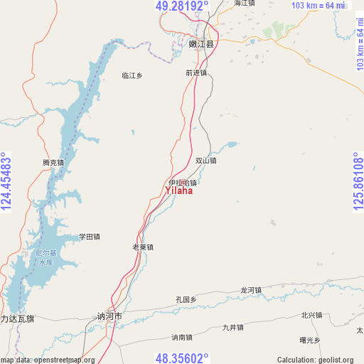
| Upper-left | 49.28192°, | 124.45483° |
| Center: | 48.82111°, | 125.15795° |
| Lower-right: | 48.35602°, | 125.86108° |
| Map W x H: | 103×102.9 km | = 64×63.9mi |
| max Lat: | 53.31946° ⇑1% North |
| Yilaha: | 48.82111° |
| min Lat: | ⇓99% South 18.22056° |
| min Long | Yilaha | max Long |
| 75.07348° | 125.15795° | 134.28917° |
| W 94.8%⇐ | ⇒5.2% E |
Elevation
Elevation of Yilaha is 261 m = 856 ft, and this is 223.8 m = 734 ft below average elevation for this country.
| Max E: |
5622 m = 18445 ft | 39.8% |
| Avg. | 484.8 m = 1591 ft | |
| Yilaha | 261 m = 856 ft | |
Min E: |
-3 m = -10 ft | 60.2% |
See also: China elevation on elevation.city.
Geographical zone
Yilaha is located in North temperate zone (between Tropic of Cancer and the Arctic Circle). Distance of this North polar circle is 1972.8 km =1225.8 mi to North.| Distance of | km | miles | from Yilaha |
|---|---|---|---|
| North Pole | 4578.7 | 2845.1 | to North |
| Arctic Circle | 1972.8 | 1225.8 | to North |
| Tropic Cancer | 2822.5 | 1753.8 | to South |
| Equator | 5428.4 | 3373.1 | to South |


Nearby cities:
15 places around Yilaha: (largest is in red/bold)
• Borong
68.1 km =42.3 mi,  225°
225°
• Changfu
38.1 km =23.7 mi,  15°
15°
• Dengteke
51.9 km =32.2 mi,  241°
241°
• E’erhe
43.2 km =26.8 mi,  353°
353°
• Hadayang
53 km =32.9 mi,  4°
4°
• Keluo
66.3 km =41.2 mi,  41°
41°
• Linjiang
33.4 km =20.8 mi,  335°
335°
• Nehe
44.5 km =27.7 mi,  212°
212°
• Nenjiang
39.5 km =24.5 mi,  6°
6°
• Nirji
62.2 km =38.6 mi, 232°
• Qianjin
31.2 km =19.4 mi, 6°
• Shuangshan
9.1 km =5.7 mi, 44°
• Tengke
38 km =23.6 mi,  303°
303°
• Wu’erke
71 km =44.1 mi, 243°
• Xiwa’ertu
67.4 km =41.9 mi,  255°
255°
Sources, notices
• [Note1] Compared only with cities in China existing in our database
• [Src1] Map data: © OpenStreetMap contributors (CC-BY-SA)
• [Src2] Other city data from geonames.org with taken over terms of usage.
• [Src3] Geographical zone / Annual Mean Temperature by Robert A. Rohde @ Wikipedia
