Shuangshan geodata
Shuangshan (Heilongjiang) is a seat of a fourth-order administrative division; located in China in Asia/Shanghai (GMT+8) time zone. In our database, there are 1268 cities with bigger population. Compared to other cities in China, 99.1% of cities are located further ↓South; 94.8% of cities are located further ←West and 60.8% of cities have lower elevation than Shuangshan. Note1


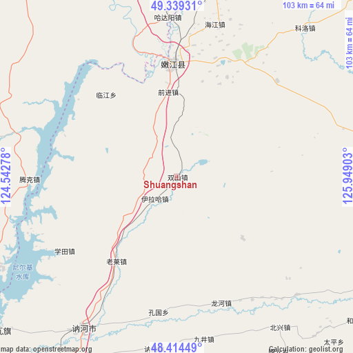
Shuangshan GPS coordinates[2]
48° 52' 44.544" North, 125° 14' 45.24" East
| Map corner | latitude | longitude |
|---|---|---|
| Upper-left | 49.33931°, | 124.54278° |
| Center: | 48.87904°, | 125.2459° |
| Lower-right: | 48.41449°, | 125.94903° |
| Map W x H: | 102.8×102.8 km | = 63.9×63.9mi |
| max Lat: | 53.31946° ⇑0.9% North |
| Shuangshan: | 48.87904° |
| min Lat: | ⇓99.1% South 18.22056° |
| min Long | Shuangshan | max Long |
| 75.07348° | 125.2459° | 134.28917° |
| W 94.8%⇐ | ⇒5.2% E |
Elevation
Elevation of Shuangshan is 268 m = 879 ft, and this is 216.8 m = 711 ft below average elevation for this country.
| Max E: |
5622 m = 18445 ft | 39.2% |
| Avg. | 484.8 m = 1591 ft | |
| Shuangshan | 268 m = 879 ft | |
Min E: |
-3 m = -10 ft | 60.8% |
See also: China elevation on elevation.city.
Geographical zone
Shuangshan is located in North temperate zone (between Tropic of Cancer and the Arctic Circle). Distance of this North polar circle is 1966.3 km =1221.8 mi to North.| Distance of | km | miles | from Shuangshan |
|---|---|---|---|
| North Pole | 4572.2 | 2841 | to North |
| Arctic Circle | 1966.3 | 1221.8 | to North |
| Tropic Cancer | 2828.9 | 1757.8 | to South |
| Equator | 5434.8 | 3377 | to South |


Nearby cities:
15 places around Shuangshan: (largest is in red/bold)
• Bayan Ewenke Minzu
73.6 km =45.7 mi,  331°
331°
• Changfu
30.5 km =19 mi,  6°
6°
• Dengteke
60.7 km =37.7 mi,  239°
239°
• E’erhe
38.3 km =23.8 mi,  342°
342°
• Hadayang
46.4 km =28.8 mi,  356°
356°
• Hongyan
72.9 km =45.3 mi, 344°
• Keluo
57.2 km =35.5 mi,  40°
40°
• Linjiang
31.4 km =19.5 mi,  319°
319°
• Nehe
53.4 km =33.2 mi,  214°
214°
• Nenjiang
32.9 km =20.4 mi, 356°
• Nirji
71.2 km =44.2 mi,  231°
231°
• Qianjin
24.7 km =15.3 mi,  353°
353°
• Tengke
40.8 km =25.4 mi,  291°
291°
• Xiwa’ertu
75.4 km =46.9 mi,  251°
251°
• Yilaha
9.1 km =5.7 mi,  224°
224°
Sources, notices
• [Note1] Compared only with cities in China existing in our database
• [Src1] Map data: © OpenStreetMap contributors (CC-BY-SA)
• [Src2] Other city data from geonames.org with taken over terms of usage.
• [Src3] Geographical zone / Annual Mean Temperature by Robert A. Rohde @ Wikipedia
