Changfu geodata
Changfu (Heilongjiang) is a seat of a fourth-order administrative division; located in China in Asia/Shanghai (GMT+8) time zone. In our database, there are 1268 cities with bigger population. Compared to other cities in China, 99.2% of cities are located further ↓South; 94.9% of cities are located further ←West and 59.1% of cities have lower elevation than Changfu. Note1


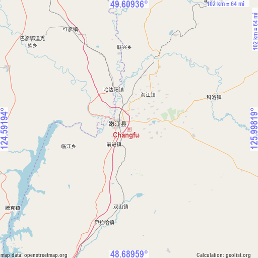
Changfu GPS coordinates[2]
49° 9' 5.796" North, 125° 17' 42.216" East
| Map corner | latitude | longitude |
|---|---|---|
| Upper-left | 49.60936°, | 124.59194° |
| Center: | 49.15161°, | 125.29506° |
| Lower-right: | 48.68959°, | 125.99819° |
| Map W x H: | 102.3×102.3 km | = 63.6×63.6mi |
| max Lat: | 53.31946° ⇑0.8% North |
| Changfu: | 49.15161° |
| min Lat: | ⇓99.2% South 18.22056° |
| min Long | Changfu | max Long |
| 75.07348° | 125.29506° | 134.28917° |
| W 94.9%⇐ | ⇒5.1% E |
Elevation
Elevation of Changfu is 248 m = 814 ft, and this is 236.8 m = 777 ft below average elevation for this country.
| Max E: |
5622 m = 18445 ft | 40.9% |
| Avg. | 484.8 m = 1591 ft | |
| Changfu | 248 m = 814 ft | |
Min E: |
-3 m = -10 ft | 59.1% |
See also: China elevation on elevation.city.
Geographical zone
Changfu is located in North temperate zone (between Tropic of Cancer and the Arctic Circle). Distance of this North polar circle is 1936 km =1203 mi to North.| Distance of | km | miles | from Changfu |
|---|---|---|---|
| North Pole | 4541.9 | 2822.2 | to North |
| Arctic Circle | 1936 | 1203 | to North |
| Tropic Cancer | 2859.2 | 1776.6 | to South |
| Equator | 5465.1 | 3395.9 | to South |


Nearby cities:
15 places around Changfu: (largest is in red/bold)
• Baiyun
68.3 km =42.4 mi,  89°
89°
• Bayan Ewenke Minzu
51.6 km =32.1 mi,  312°
312°
• E’erhe
16.3 km =10.1 mi,  292°
292°
• Hadayang
17.2 km =10.7 mi,  339°
339°
• Hongyan
46.2 km =28.7 mi,  329°
329°
• Keluo
36.2 km =22.5 mi,  69°
69°
• Kuilehe
74.8 km =46.5 mi, 305°
• Kuleqi
78.6 km =48.8 mi,  316°
316°
• Linjiang
24.7 km =15.3 mi,  255°
255°
• Nenjiang
6.2 km =3.9 mi, 294°
• Oukenhe
79.5 km =49.4 mi, 333°
• Qianjin
8.5 km =5.3 mi,  227°
227°
• Shuangshan
30.5 km =19 mi,  186°
186°
• Tengke
44.4 km =27.6 mi,  249°
249°
• Yilaha
38.1 km =23.7 mi,  195°
195°
Sources, notices
• [Note1] Compared only with cities in China existing in our database
• [Src1] Map data: © OpenStreetMap contributors (CC-BY-SA)
• [Src2] Other city data from geonames.org with taken over terms of usage.
• [Src3] Geographical zone / Annual Mean Temperature by Robert A. Rohde @ Wikipedia
