Keluo geodata
Keluo (Heilongjiang) is a seat of a fourth-order administrative division; located in China in Asia/Shanghai (GMT+8) time zone. In our database, there are 1268 cities with bigger population. Compared to other cities in China, 99.3% of cities are located further ↓South; 95.3% of cities are located further ←West and 60.6% of cities have lower elevation than Keluo. Note1


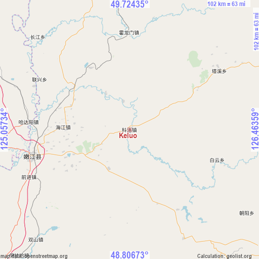
Keluo GPS coordinates[2]
49° 16' 3.612" North, 125° 45' 37.656" East
| Map corner | latitude | longitude |
|---|---|---|
| Upper-left | 49.72435°, | 125.05734° |
| Center: | 49.26767°, | 125.76046° |
| Lower-right: | 48.80673°, | 126.46359° |
| Map W x H: | 102×102 km | = 63.4×63.4mi |
| max Lat: | 53.31946° ⇑0.7% North |
| Keluo: | 49.26767° |
| min Lat: | ⇓99.3% South 18.22056° |
| min Long | Keluo | max Long |
| 75.07348° | 125.76046° | 134.28917° |
| W 95.3%⇐ | ⇒4.7% E |
Elevation
Elevation of Keluo is 267 m = 876 ft, and this is 217.8 m = 715 ft below average elevation for this country.
| Max E: |
5622 m = 18445 ft | 39.4% |
| Avg. | 484.8 m = 1591 ft | |
| Keluo | 267 m = 876 ft | |
Min E: |
-3 m = -10 ft | 60.6% |
See also: China elevation on elevation.city.
Geographical zone
Keluo is located in North temperate zone (between Tropic of Cancer and the Arctic Circle). Distance of this North polar circle is 1923.1 km =1195 mi to North.| Distance of | km | miles | from Keluo |
|---|---|---|---|
| North Pole | 4529 | 2814.2 | to North |
| Arctic Circle | 1923.1 | 1195 | to North |
| Tropic Cancer | 2872.1 | 1784.6 | to South |
| Equator | 5478.1 | 3403.9 | to South |


Nearby cities:
15 places around Keluo: (largest is in red/bold)
• Baiyun
36.5 km =22.7 mi,  109°
109°
• Bayan Ewenke Minzu
75.2 km =46.7 mi,  286°
286°
• Changfu
36.2 km =22.5 mi,  249°
249°
• E’erhe
49.4 km =30.7 mi,  262°
262°
• Hadayang
40 km =24.9 mi,  274°
274°
• Hongyan
63 km =39.1 mi,  295°
295°
• Huolongmen
59.4 km =36.9 mi,  1°
1°
• Linjiang
60.8 km =37.8 mi, 251°
• Nenjiang
40.8 km =25.4 mi, 255°
• Oukenhe
90.4 km =56.2 mi,  310°
310°
• Qianjin
44.2 km =27.5 mi,  244°
244°
• Shuangshan
57.2 km =35.5 mi,  220°
220°
• Tengke
80.5 km =50 mi, 249°
• Yilaha
66.3 km =41.2 mi, 221°
• Zhengyangshan
89.1 km =55.4 mi,  91°
91°
Sources, notices
• [Note1] Compared only with cities in China existing in our database
• [Src1] Map data: © OpenStreetMap contributors (CC-BY-SA)
• [Src2] Other city data from geonames.org with taken over terms of usage.
• [Src3] Geographical zone / Annual Mean Temperature by Robert A. Rohde @ Wikipedia
