Xinglong geodata
Xinglong (Heilongjiang) is a seat of a fourth-order administrative division; located in China in Asia/Shanghai (GMT+8) time zone. In our database, there are 1268 cities with bigger population. Compared to other cities in China, 98.6% of cities are located further ↓South; 93.4% of cities are located further ←West and 53.1% of cities have lower elevation than Xinglong. Note1


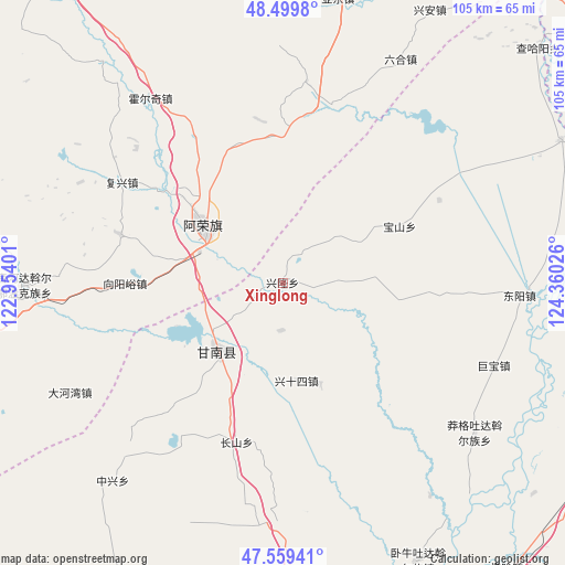
Xinglong GPS coordinates[2]
48° 1' 54.3" North, 123° 39' 25.668" East
| Map corner | latitude | longitude |
|---|---|---|
| Upper-left | 48.4998°, | 122.95401° |
| Center: | 48.03175°, | 123.65713° |
| Lower-right: | 47.55941°, | 124.36026° |
| Map W x H: | 104.6×104.6 km | = 65×65mi |
| max Lat: | 53.31946° ⇑1.4% North |
| Xinglong: | 48.03175° |
| min Lat: | ⇓98.6% South 18.22056° |
| min Long | Xinglong | max Long |
| 75.07348° | 123.65713° | 134.28917° |
| W 93.4%⇐ | ⇒6.6% E |
Elevation
Elevation of Xinglong is 189 m = 620 ft, and this is 295.8 m = 970 ft below average elevation for this country.
| Max E: |
5622 m = 18445 ft | 46.9% |
| Avg. | 484.8 m = 1591 ft | |
| Xinglong | 189 m = 620 ft | |
Min E: |
-3 m = -10 ft | 53.1% |
See also: China elevation on elevation.city.
Geographical zone
Xinglong is located in North temperate zone (between Tropic of Cancer and the Arctic Circle). Distance of this North polar circle is 2060.5 km =1280.3 mi to North.| Distance of | km | miles | from Xinglong |
|---|---|---|---|
| North Pole | 4666.4 | 2899.6 | to North |
| Arctic Circle | 2060.5 | 1280.3 | to North |
| Tropic Cancer | 2734.7 | 1699.3 | to South |
| Equator | 5340.6 | 3318.5 | to South |


Nearby cities:
15 places around Xinglong: (largest is in red/bold)
• Baoshan
24 km =14.9 mi,  63°
63°
• Changshan
30.7 km =19.1 mi,  196°
196°
• Dahewan
44.3 km =27.5 mi,  242°
242°
• Dongyang
44 km =27.3 mi,  92°
92°
• Fuxing
35 km =21.7 mi,  302°
302°
• Gannan
17.3 km =10.7 mi,  221°
221°
• Gushan
34.3 km =21.3 mi,  13°
13°
• Honghualiangzi
31.8 km =19.8 mi,  286°
286°
• Huo’erqi
41.9 km =26 mi,  324°
324°
• Jubao
42 km =26.1 mi,  111°
111°
• Manggetu Dawo’er Zu
45.2 km =28.1 mi,  127°
127°
• Naji
17.8 km =11.1 mi, 304°
• Ruiting
43.7 km =27.2 mi,  170°
170°
• Sandaogou
19.7 km =12.2 mi,  263°
263°
• Yinhe
8.8 km =5.5 mi,  183°
183°
Sources, notices
• [Note1] Compared only with cities in China existing in our database
• [Src1] Map data: © OpenStreetMap contributors (CC-BY-SA)
• [Src2] Other city data from geonames.org with taken over terms of usage.
• [Src3] Geographical zone / Annual Mean Temperature by Robert A. Rohde @ Wikipedia
