Yinhe geodata
Yinhe (Heilongjiang) is a seat of a fourth-order administrative division; located in China in Asia/Shanghai (GMT+8) time zone. In our database, there are 1268 cities with bigger population. Compared to other cities in China, 98.5% of cities are located further ↓South; 93.4% of cities are located further ←West and 52% of cities have lower elevation than Yinhe. Note1


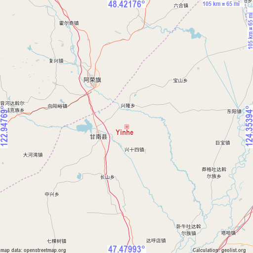
Yinhe GPS coordinates[2]
47° 57' 10.764" North, 123° 39' 2.916" East
| Map corner | latitude | longitude |
|---|---|---|
| Upper-left | 48.42176°, | 122.94769° |
| Center: | 47.95299°, | 123.65081° |
| Lower-right: | 47.47993°, | 124.35394° |
| Map W x H: | 104.7×104.7 km | = 65.1×65.1mi |
| max Lat: | 53.31946° ⇑1.5% North |
| Yinhe: | 47.95299° |
| min Lat: | ⇓98.5% South 18.22056° |
| min Long | Yinhe | max Long |
| 75.07348° | 123.65081° | 134.28917° |
| W 93.4%⇐ | ⇒6.6% E |
Elevation
Elevation of Yinhe is 181 m = 594 ft, and this is 303.8 m = 997 ft below average elevation for this country.
| Max E: |
5622 m = 18445 ft | 48% |
| Avg. | 484.8 m = 1591 ft | |
| Yinhe | 181 m = 594 ft | |
Min E: |
-3 m = -10 ft | 52% |
See also: China elevation on elevation.city.
Geographical zone
Yinhe is located in North temperate zone (between Tropic of Cancer and the Arctic Circle). Distance of this North polar circle is 2069.3 km =1285.8 mi to North.| Distance of | km | miles | from Yinhe |
|---|---|---|---|
| North Pole | 4675.2 | 2905 | to North |
| Arctic Circle | 2069.3 | 1285.8 | to North |
| Tropic Cancer | 2726 | 1693.9 | to South |
| Equator | 5331.9 | 3313.1 | to South |


Nearby cities:
15 places around Yinhe: (largest is in red/bold)
• Baoshan
29.3 km =18.2 mi,  48°
48°
• Changshan
22.2 km =13.8 mi,  201°
201°
• Dahewan
40.7 km =25.3 mi,  253°
253°
• Dongyang
44.9 km =27.9 mi,  81°
81°
• Fuxing
40 km =24.9 mi,  313°
313°
• Gannan
11.8 km =7.3 mi, 248°
• Gushan
43 km =26.7 mi,  11°
11°
• Honghualiangzi
34.9 km =21.7 mi,  300°
300°
• Jubao
40.2 km =25 mi,  99°
99°
• Manggetu Dawo’er Zu
40.8 km =25.4 mi,  117°
117°
• Naji
23.6 km =14.7 mi,  322°
322°
• Ruiting
35.2 km =21.9 mi,  167°
167°
• Sandaogou
20.2 km =12.6 mi,  288°
288°
• Xinglong
8.8 km =5.5 mi,  3°
3°
• Zhongxing
42 km =26.1 mi,  228°
228°
Sources, notices
• [Note1] Compared only with cities in China existing in our database
• [Src1] Map data: © OpenStreetMap contributors (CC-BY-SA)
• [Src2] Other city data from geonames.org with taken over terms of usage.
• [Src3] Geographical zone / Annual Mean Temperature by Robert A. Rohde @ Wikipedia
