Xilinhe geodata
Xilinhe (Jilin) is a seat of a fourth-order administrative division; located in China in Asia/Shanghai (GMT+8) time zone. In our database, there are 1268 cities with bigger population. Compared to other cities in China, 91.8% of cities are located further ↓South; 98.5% of cities are located further ←West and 62.2% of cities have lower elevation than Xilinhe. Note1


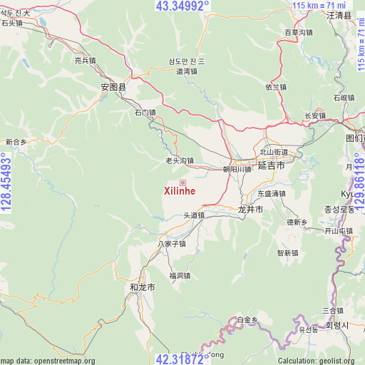
Xilinhe GPS coordinates[2]
42° 50' 11.292" North, 129° 9' 28.98" East
| Map corner | latitude | longitude |
|---|---|---|
| Upper-left | 43.34992°, | 128.45493° |
| Center: | 42.83647°, | 129.15805° |
| Lower-right: | 42.31872°, | 129.86118° |
| Map W x H: | 114.7×114.7 km | = 71.3×71.3mi |
| max Lat: | 53.31946° ⇑8.2% North |
| Xilinhe: | 42.83647° |
| min Lat: | ⇓91.8% South 18.22056° |
| min Long | Xilinhe | max Long |
| 75.07348° | 129.15805° | 134.28917° |
| W 98.5%⇐ | ⇒1.5% E |
Elevation
Elevation of Xilinhe is 286 m = 938 ft, and this is 198.8 m = 652 ft below average elevation for this country.
| Max E: |
5622 m = 18445 ft | 37.8% |
| Avg. | 484.8 m = 1591 ft | |
| Xilinhe | 286 m = 938 ft | |
Min E: |
-3 m = -10 ft | 62.2% |
See also: China elevation on elevation.city.
Geographical zone
Xilinhe is located in North temperate zone (between Tropic of Cancer and the Arctic Circle). Distance of this Northern Tropic circle is 2157 km =1340.3 mi to South.| Distance of | km | miles | from Xilinhe |
|---|---|---|---|
| North Pole | 5244.1 | 3258.5 | to North |
| Arctic Circle | 2638.2 | 1639.3 | to North |
| Tropic Cancer | 2157 | 1340.3 | to South |
| Equator | 4763 | 2959.6 | to South |


Nearby cities:
15 places around Xilinhe: (largest is in red/bold)
• Bajiazi
19.3 km =12 mi,  190°
190°
• Beixinjie
10.3 km =6.4 mi,  161°
161°
• Chaoyangchuan
17.3 km =10.7 mi,  73°
73°
• Dongshengyong
28.1 km =17.5 mi,  96°
96°
• Erdao
16.3 km =10.1 mi,  198°
198°
• Fudong
29.2 km =18.1 mi,  181°
181°
• Helong
35.5 km =22.1 mi, 201°
• Longjing
22.8 km =14.2 mi,  108°
108°
• Mingyue
35.7 km =22.2 mi,  327°
327°
• Pucheng
17.1 km =10.6 mi,  127°
127°
• Shimen
24.7 km =15.3 mi, 332°
• Tongfosi
8.9 km =5.5 mi,  50°
50°
• Tushan
25.3 km =15.7 mi, 203°
• Xiaoying
30.7 km =19.1 mi, 74°
• Yanji
29.6 km =18.4 mi, 74°
Sources, notices
• [Note1] Compared only with cities in China existing in our database
• [Src1] Map data: © OpenStreetMap contributors (CC-BY-SA)
• [Src2] Other city data from geonames.org with taken over terms of usage.
• [Src3] Geographical zone / Annual Mean Temperature by Robert A. Rohde @ Wikipedia
