Erdao geodata
Erdao (Jilin) is a seat of a fourth-order administrative division; located in China in Asia/Shanghai (GMT+8) time zone. In our database, there are 1268 cities with bigger population. Compared to other cities in China, 91.6% of cities are located further ↓South; 98.5% of cities are located further ←West and 66.1% of cities have lower elevation than Erdao. Note1


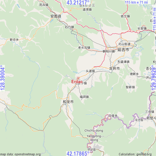
Erdao GPS coordinates[2]
42° 41' 51.216" North, 129° 5' 35.376" East
| Map corner | latitude | longitude |
|---|---|---|
| Upper-left | 43.21217°, | 128.39004° |
| Center: | 42.69756°, | 129.09316° |
| Lower-right: | 42.17865°, | 129.79629° |
| Map W x H: | 114.9×114.9 km | = 71.4×71.4mi |
| max Lat: | 53.31946° ⇑8.4% North |
| Erdao: | 42.69756° |
| min Lat: | ⇓91.6% South 18.22056° |
| min Long | Erdao | max Long |
| 75.07348° | 129.09316° | 134.28917° |
| W 98.5%⇐ | ⇒1.5% E |
Elevation
Elevation of Erdao is 346 m = 1135 ft, and this is 138.8 m = 455 ft below average elevation for this country.
| Max E: |
5622 m = 18445 ft | 33.9% |
| Avg. | 484.8 m = 1591 ft | |
| Erdao | 346 m = 1135 ft | |
Min E: |
-3 m = -10 ft | 66.1% |
See also: China elevation on elevation.city.
Geographical zone
Erdao is located in North temperate zone (between Tropic of Cancer and the Arctic Circle). Distance of this Northern Tropic circle is 2141.6 km =1330.7 mi to South.| Distance of | km | miles | from Erdao |
|---|---|---|---|
| North Pole | 5259.5 | 3268.1 | to North |
| Arctic Circle | 2653.7 | 1648.9 | to North |
| Tropic Cancer | 2141.6 | 1330.7 | to South |
| Equator | 4747.5 | 2950 | to South |


Nearby cities:
15 places around Erdao: (largest is in red/bold)
• Bajiazi
3.9 km =2.4 mi,  154°
154°
• Beixinjie
10.3 km =6.4 mi,  56°
56°
• Chaoyangchuan
29.8 km =18.5 mi,  47°
47°
• Dalazi
38.8 km =24.1 mi,  99°
99°
• Dongshengyong
35.5 km =22.1 mi,  69°
69°
• Fudong
14.4 km =8.9 mi,  161°
161°
• Helong
19.2 km =11.9 mi,  204°
204°
• Longjing
28.2 km =17.5 mi, 73°
• Pucheng
19.6 km =12.2 mi, 74°
• Shimen
37.9 km =23.5 mi,  350°
350°
• Tongfosi
24.4 km =15.2 mi,  30°
30°
• Tushan
9.1 km =5.7 mi,  212°
212°
• Xianpudong
37.4 km =23.2 mi,  137°
137°
• Xilinhe
16.3 km =10.1 mi,  18°
18°
• Yanji
41.1 km =25.5 mi, 55°
Sources, notices
• [Note1] Compared only with cities in China existing in our database
• [Src1] Map data: © OpenStreetMap contributors (CC-BY-SA)
• [Src2] Other city data from geonames.org with taken over terms of usage.
• [Src3] Geographical zone / Annual Mean Temperature by Robert A. Rohde @ Wikipedia
