Xiaochengzi geodata
Xiaochengzi (Liaoning) is a seat of a fourth-order administrative division; located in China in Asia/Shanghai (GMT+8) time zone. In our database, there are 1268 cities with bigger population. Compared to other cities in China, 91.9% of cities are located further ↓South; 92.9% of cities are located further ←West and 55.6% of cities have higher elevation than Xiaochengzi. Note1


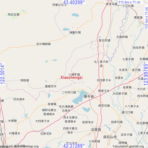
Xiaochengzi GPS coordinates[2]
42° 53' 23.964" North, 123° 12' 16.272" East
| Map corner | latitude | longitude |
|---|---|---|
| Upper-left | 43.40299°, | 122.5014° |
| Center: | 42.88999°, | 123.20452° |
| Lower-right: | 42.37269°, | 123.90765° |
| Map W x H: | 114.6×114.6 km | = 71.2×71.2mi |
| max Lat: | 53.31946° ⇑8.1% North |
| Xiaochengzi: | 42.88999° |
| min Lat: | ⇓91.9% South 18.22056° |
| min Long | Xiaochengzi | max Long |
| 75.07348° | 123.20452° | 134.28917° |
| W 92.9%⇐ | ⇒7.1% E |
Elevation
Elevation of Xiaochengzi is 127 m = 417 ft, and this is 357.8 m = 1174 ft below average elevation for this country.
| Max E: |
5622 m = 18445 ft | 55.6% |
| Avg. | 484.8 m = 1591 ft | |
| Xiaochengzi | 127 m = 417 ft | |
Min E: |
-3 m = -10 ft | 44.4% |
See also: China elevation on elevation.city.
Geographical zone
Xiaochengzi is located in North temperate zone (between Tropic of Cancer and the Arctic Circle). Distance of this Northern Tropic circle is 2163 km =1344 mi to South.| Distance of | km | miles | from Xiaochengzi |
|---|---|---|---|
| North Pole | 5238.1 | 3254.8 | to North |
| Arctic Circle | 2632.3 | 1635.6 | to North |
| Tropic Cancer | 2163 | 1344 | to South |
| Equator | 4768.9 | 2963.3 | to South |


Nearby cities:
15 places around Xiaochengzi: (largest is in red/bold)
• Beisijiazi
23.4 km =14.5 mi,  101°
101°
• Dasijiazi
38.3 km =23.8 mi,  112°
112°
• Dongguantun
24.9 km =15.5 mi,  151°
151°
• Dongsheng
27.1 km =16.8 mi,  192°
192°
• Erniusuokou
14.3 km =8.9 mi,  196°
196°
• Haizhouwobao
14.6 km =9.1 mi,  68°
68°
• Haoguantun
33.2 km =20.6 mi,  136°
136°
• Jinjia
42 km =26.1 mi, 103°
• Kangping
20.5 km =12.7 mi, 144°
• Laowobao
27.2 km =16.9 mi,  80°
80°
• Liangjiazi
26 km =16.2 mi,  118°
118°
• Liushutun
35.1 km =21.8 mi,  213°
213°
• Xiguantun Muguzu Manzuxiang
35.2 km =21.9 mi, 185°
• Xizhahaqi
35.2 km =21.9 mi,  227°
227°
• Zhangqiang
28.8 km =17.9 mi,  217°
217°
Sources, notices
• [Note1] Compared only with cities in China existing in our database
• [Src1] Map data: © OpenStreetMap contributors (CC-BY-SA)
• [Src2] Other city data from geonames.org with taken over terms of usage.
• [Src3] Geographical zone / Annual Mean Temperature by Robert A. Rohde @ Wikipedia
