Songjiang geodata
Songjiang (Jilin) is a seat of a fourth-order administrative division; located in China in Asia/Shanghai (GMT+8) time zone. In our database, there are 1268 cities with bigger population. Compared to other cities in China, 91.4% of cities are located further ↓South; 98.1% of cities are located further ←West and 76.5% of cities have lower elevation than Songjiang. Note1


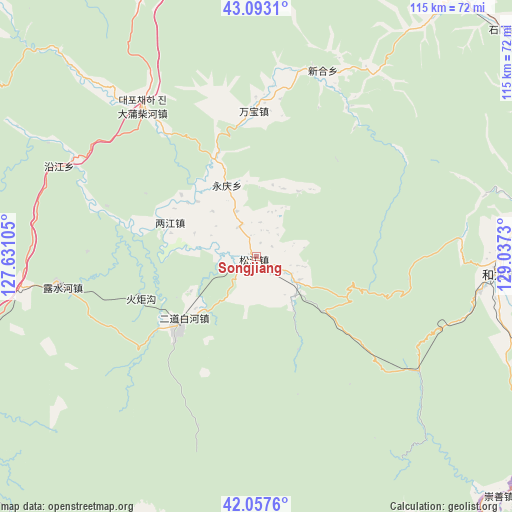
Songjiang GPS coordinates[2]
42° 34' 39" North, 128° 20' 3.012" East
| Map corner | latitude | longitude |
|---|---|---|
| Upper-left | 43.0931°, | 127.63105° |
| Center: | 42.5775°, | 128.33417° |
| Lower-right: | 42.0576°, | 129.0373° |
| Map W x H: | 115.1×115.1 km | = 71.5×71.5mi |
| max Lat: | 53.31946° ⇑8.6% North |
| Songjiang: | 42.5775° |
| min Lat: | ⇓91.4% South 18.22056° |
| min Long | Songjiang | max Long |
| 75.07348° | 128.33417° | 134.28917° |
| W 98.1%⇐ | ⇒1.9% E |
Elevation
Elevation of Songjiang is 561 m = 1841 ft, and this is 76.2 m = 250 ft above average elevation for this country.
| Max E: |
5622 m = 18445 ft | 23.5% |
| Songjiang | 561 m 1841 ft | |
| Avg. | 484.8 m = 1591 ft | |
Min E: |
-3 m = -10 ft | 76.5% |
See also: China elevation on elevation.city.
Geographical zone
Songjiang is located in North temperate zone (between Tropic of Cancer and the Arctic Circle). Distance of this Northern Tropic circle is 2128.3 km =1322.5 mi to South.| Distance of | km | miles | from Songjiang |
|---|---|---|---|
| North Pole | 5272.9 | 3276.4 | to North |
| Arctic Circle | 2667 | 1657.2 | to North |
| Tropic Cancer | 2128.3 | 1322.5 | to South |
| Equator | 4734.2 | 2941.7 | to South |


Nearby cities:
15 places around Songjiang: (largest is in red/bold)
• Baishuitan
48.1 km =29.9 mi,  294°
294°
• Bajiazi
64.5 km =40.1 mi,  81°
81°
• Dadianzi
32.9 km =20.4 mi,  358°
358°
• Dapuchaihe
41.8 km =26 mi,  323°
323°
• Dashahe
17.4 km =10.8 mi,  337°
337°
• Dongjiang
20.7 km =12.9 mi, 292°
• Erdao
63.5 km =39.5 mi, 77°
• Erdaobaihe
25 km =15.5 mi,  227°
227°
• Fudong
66.6 km =41.4 mi,  90°
90°
• Helong
54.5 km =33.9 mi, 94°
• Lushuihe
45.6 km =28.3 mi,  261°
261°
• Sandao
10.9 km =6.8 mi,  120°
120°
• Shiqi
45 km =28 mi,  20°
20°
• Tushan
57.6 km =35.8 mi, 84°
• Xiaoshahe
7.6 km =4.7 mi,  334°
334°
Sources, notices
• [Note1] Compared only with cities in China existing in our database
• [Src1] Map data: © OpenStreetMap contributors (CC-BY-SA)
• [Src2] Other city data from geonames.org with taken over terms of usage.
• [Src3] Geographical zone / Annual Mean Temperature by Robert A. Rohde @ Wikipedia
