Dapuchaihe geodata
Dapuchaihe (Jilin) is a seat of a fourth-order administrative division; located in China in Asia/Shanghai (GMT+8) time zone. In our database, there are 1268 cities with bigger population. Compared to other cities in China, 91.8% of cities are located further ↓South; 98% of cities are located further ←West and 76.6% of cities have lower elevation than Dapuchaihe. Note1


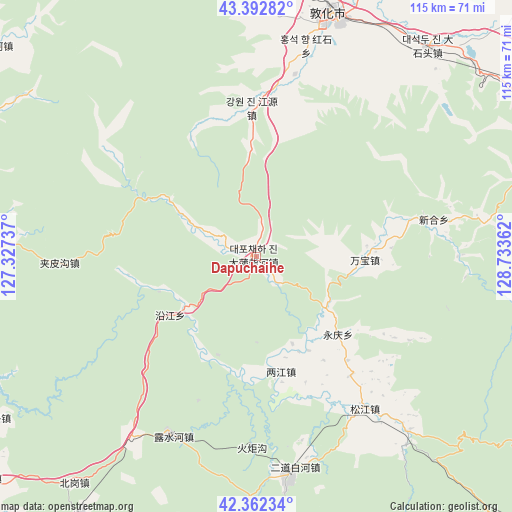
Dapuchaihe GPS coordinates[2]
42° 52' 47.028" North, 128° 1' 49.764" East
| Map corner | latitude | longitude |
|---|---|---|
| Upper-left | 43.39282°, | 127.32737° |
| Center: | 42.87973°, | 128.03049° |
| Lower-right: | 42.36234°, | 128.73362° |
| Map W x H: | 114.6×114.6 km | = 71.2×71.2mi |
| max Lat: | 53.31946° ⇑8.2% North |
| Dapuchaihe: | 42.87973° |
| min Lat: | ⇓91.8% South 18.22056° |
| min Long | Dapuchaihe | max Long |
| 75.07348° | 128.03049° | 134.28917° |
| W 98%⇐ | ⇒2% E |
Elevation
Elevation of Dapuchaihe is 563 m = 1847 ft, and this is 78.2 m = 257 ft above average elevation for this country.
| Max E: |
5622 m = 18445 ft | 23.4% |
| Dapuchaihe | 563 m 1847 ft | |
| Avg. | 484.8 m = 1591 ft | |
Min E: |
-3 m = -10 ft | 76.6% |
See also: China elevation on elevation.city.
Geographical zone
Dapuchaihe is located in North temperate zone (between Tropic of Cancer and the Arctic Circle). Distance of this Northern Tropic circle is 2161.9 km =1343.3 mi to South.| Distance of | km | miles | from Dapuchaihe |
|---|---|---|---|
| North Pole | 5239.3 | 3255.5 | to North |
| Arctic Circle | 2633.4 | 1636.3 | to North |
| Tropic Cancer | 2161.9 | 1343.3 | to South |
| Equator | 4767.8 | 2962.6 | to South |


Nearby cities:
15 places around Dapuchaihe: (largest is in red/bold)
• Baishuitan
23 km =14.3 mi,  234°
234°
• Beigang
65.3 km =40.6 mi,  218°
218°
• Dadianzi
24 km =14.9 mi,  91°
91°
• Dashahe
25.3 km =15.7 mi,  133°
133°
• Dashitou
61.5 km =38.2 mi,  39°
39°
• Dongjiang
26.3 km =16.3 mi,  167°
167°
• Dunhua
57.4 km =35.7 mi,  17°
17°
• Erdaobaihe
51 km =31.7 mi, 172°
• Erdaocha
44.2 km =27.5 mi,  268°
268°
• Laojinchang
55.2 km =34.3 mi, 273°
• Lushuihe
44.9 km =27.9 mi,  206°
206°
• Sandao
52 km =32.3 mi,  138°
138°
• Shiqi
41.3 km =25.7 mi,  78°
78°
• Songjiang
41.8 km =26 mi, 143°
• Xiaoshahe
34.3 km =21.3 mi, 141°
Sources, notices
• [Note1] Compared only with cities in China existing in our database
• [Src1] Map data: © OpenStreetMap contributors (CC-BY-SA)
• [Src2] Other city data from geonames.org with taken over terms of usage.
• [Src3] Geographical zone / Annual Mean Temperature by Robert A. Rohde @ Wikipedia
