Sankeyushu geodata
Sankeyushu (Jilin) is a seat of a fourth-order administrative division; located in China in Asia/Shanghai (GMT+8) time zone. In our database, there are 1268 cities with bigger population. Compared to other cities in China, 90.5% of cities are located further ↓South; 94.9% of cities are located further ←West and 71.5% of cities have lower elevation than Sankeyushu. Note1


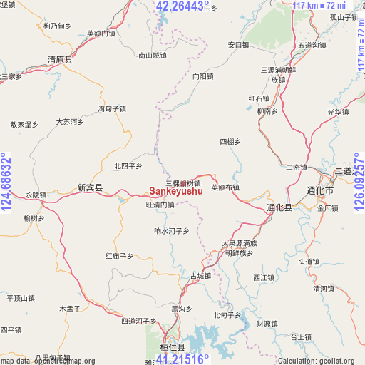
Sankeyushu GPS coordinates[2]
41° 44' 30.984" North, 125° 23' 21.984" East
| Map corner | latitude | longitude |
|---|---|---|
| Upper-left | 42.26443°, | 124.68632° |
| Center: | 41.74194°, | 125.38944° |
| Lower-right: | 41.21516°, | 126.09257° |
| Map W x H: | 116.7×116.7 km | = 72.5×72.5mi |
| max Lat: | 53.31946° ⇑9.5% North |
| Sankeyushu: | 41.74194° |
| min Lat: | ⇓90.5% South 18.22056° |
| min Long | Sankeyushu | max Long |
| 75.07348° | 125.38944° | 134.28917° |
| W 94.9%⇐ | ⇒5.1% E |
Elevation
Elevation of Sankeyushu is 440 m = 1444 ft, and this is 44.8 m = 147 ft below average elevation for this country.
| Max E: |
5622 m = 18445 ft | 28.5% |
| Avg. | 484.8 m = 1591 ft | |
| Sankeyushu | 440 m = 1444 ft | |
Min E: |
-3 m = -10 ft | 71.5% |
See also: China elevation on elevation.city.
Geographical zone
Sankeyushu is located in North temperate zone (between Tropic of Cancer and the Arctic Circle). Distance of this Northern Tropic circle is 2035.3 km =1264.7 mi to South.| Distance of | km | miles | from Sankeyushu |
|---|---|---|---|
| North Pole | 5365.8 | 3334.2 | to North |
| Arctic Circle | 2759.9 | 1714.9 | to North |
| Tropic Cancer | 2035.3 | 1264.7 | to South |
| Equator | 4641.3 | 2884 | to South |


Nearby cities:
15 places around Sankeyushu: (largest is in red/bold)
• Dachuan
24.9 km =15.5 mi,  150°
150°
• Daduling
28.6 km =17.8 mi,  118°
118°
• Daquanyuan
27.5 km =17.1 mi,  139°
139°
• Dasuhe
40.9 km =25.4 mi,  298°
298°
• Ermi
36.9 km =22.9 mi,  82°
82°
• Gangou
30.1 km =18.7 mi,  63°
63°
• Hulutao
46 km =28.6 mi, 82°
• Jianchanggou
6 km =3.7 mi,  306°
306°
• Jiangdianzi
40.6 km =25.2 mi, 138°
• Jindou
25.4 km =15.8 mi,  99°
99°
• Kuaidamao
30.8 km =19.1 mi,  108°
108°
• Sipeng
20.2 km =12.6 mi,  48°
48°
• Tonghua
44.6 km =27.7 mi,  93°
93°
• Tongshanjie
39.7 km =24.7 mi,  74°
74°
• Ying’ebu
13.9 km =8.6 mi, 95°
Sources, notices
• [Note1] Compared only with cities in China existing in our database
• [Src1] Map data: © OpenStreetMap contributors (CC-BY-SA)
• [Src2] Other city data from geonames.org with taken over terms of usage.
• [Src3] Geographical zone / Annual Mean Temperature by Robert A. Rohde @ Wikipedia
