Qitai geodata
Qitai (Inner Mongolia) is a seat of a third-order administrative division; located in China in Asia/Shanghai (GMT+8) time zone. In our database, there are 1268 cities with bigger population. Compared to other cities in China, 90.2% of cities are located further ↓South; 54.1% of cities are located further →East and 90.1% of cities have lower elevation than Qitai. Note1


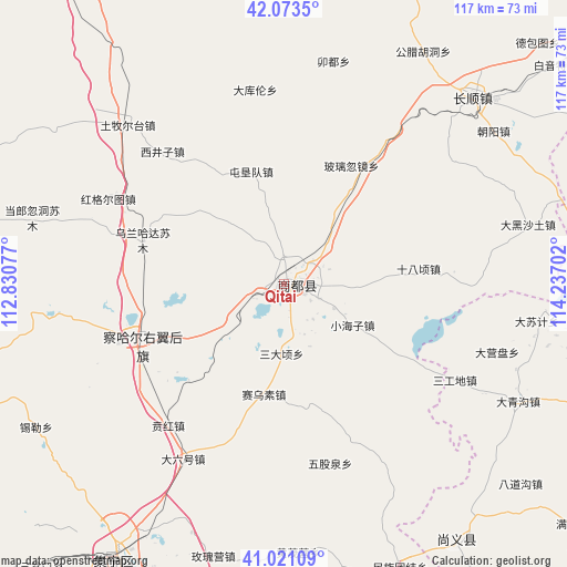
Qitai GPS coordinates[2]
41° 32' 57.984" North, 113° 32' 2.004" East
| Map corner | latitude | longitude |
|---|---|---|
| Upper-left | 42.0735°, | 112.83077° |
| Center: | 41.54944°, | 113.53389° |
| Lower-right: | 41.02109°, | 114.23702° |
| Map W x H: | 117×117 km | = 72.7×72.7mi |
| max Lat: | 53.31946° ⇑9.8% North |
| Qitai: | 41.54944° |
| min Lat: | ⇓90.2% South 18.22056° |
| min Long | Qitai | max Long |
| 75.07348° | 113.53389° | 134.28917° |
| W 45.9%⇐ | ⇒54.1% E |
Elevation
Elevation of Qitai is 1371 m = 4498 ft, and this is 886.2 m = 2907 ft above average elevation for this country.
| Max E: |
5622 m = 18445 ft | 9.9% |
| Qitai | 1371 m 4498 ft | |
| Avg. | 484.8 m = 1591 ft | |
Min E: |
-3 m = -10 ft | 90.1% |
See also: China elevation on elevation.city.
Geographical zone
Qitai is located in North temperate zone (between Tropic of Cancer and the Arctic Circle). Distance of this Northern Tropic circle is 2013.9 km =1251.4 mi to South.| Distance of | km | miles | from Qitai |
|---|---|---|---|
| North Pole | 5387.2 | 3347.4 | to North |
| Arctic Circle | 2781.3 | 1728.2 | to North |
| Tropic Cancer | 2013.9 | 1251.4 | to South |
| Equator | 4619.9 | 2870.7 | to South |


Nearby cities:
15 places around Qitai: (largest is in red/bold)
• Aguitu
41.3 km =25.7 mi,  307°
307°
• Baiyin Chagan
31.1 km =19.3 mi,  249°
249°
• Benhong
37.5 km =23.3 mi,  220°
220°
• Chahannao
56.1 km =34.9 mi,  276°
276°
• Changshun
53.8 km =33.4 mi,  45°
45°
• Daliuhao
41.3 km =25.7 mi,  209°
209°
• Danglang Hudong
53.6 km =33.3 mi,  285°
285°
• Hayan Hudong
22.4 km =13.9 mi,  239°
239°
• Hongge’ertu
35.6 km =22.1 mi,  297°
297°
• Jigun Tala
55.9 km =34.7 mi, 299°
• Shimenkou
27.6 km =17.1 mi, 224°
• Shiyaogou
48.4 km =30.1 mi,  233°
233°
• Tumu’ertai
46 km =28.6 mi,  315°
315°
• Wulan Hada
30.3 km =18.8 mi, 287°
• Xilei
59 km =36.7 mi, 239°
Sources, notices
• [Note1] Compared only with cities in China existing in our database
• [Src1] Map data: © OpenStreetMap contributors (CC-BY-SA)
• [Src2] Other city data from geonames.org with taken over terms of usage.
• [Src3] Geographical zone / Annual Mean Temperature by Robert A. Rohde @ Wikipedia
