Baiyin Chagan geodata
Baiyin Chagan (Inner Mongolia) is a seat of a third-order administrative division; located in China in Asia/Shanghai (GMT+8) time zone. In our database, there are 1268 cities with bigger population. Compared to other cities in China, 90.1% of cities are located further ↓South; 56.4% of cities are located further →East and 90.7% of cities have lower elevation than Baiyin Chagan. Note1


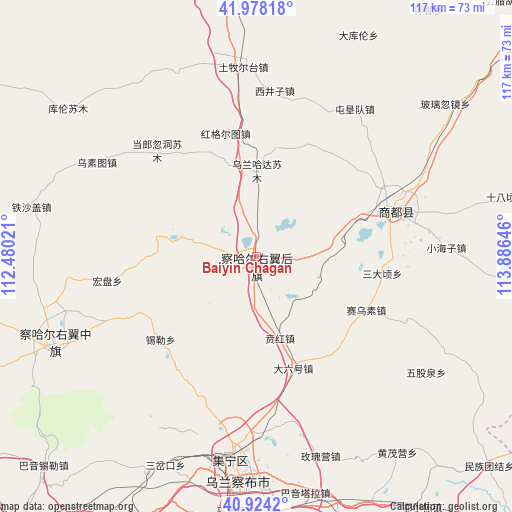
Baiyin Chagan GPS coordinates[2]
41° 27' 11.988" North, 113° 10' 59.988" East
| Map corner | latitude | longitude |
|---|---|---|
| Upper-left | 41.97818°, | 112.48021° |
| Center: | 41.45333°, | 113.18333° |
| Lower-right: | 40.9242°, | 113.88646° |
| Map W x H: | 117.2×117.2 km | = 72.8×72.8mi |
| max Lat: | 53.31946° ⇑9.9% North |
| Baiyin Chagan: | 41.45333° |
| min Lat: | ⇓90.1% South 18.22056° |
| min Long | Baiyin Chagan | max Long |
| 75.07348° | 113.18333° | 134.28917° |
| W 43.6%⇐ | ⇒56.4% E |
Elevation
Elevation of Baiyin Chagan is 1422 m = 4665 ft, and this is 937.2 m = 3075 ft above average elevation for this country.
| Max E: |
5622 m = 18445 ft | 9.3% |
| Baiyin Chagan | 1422 m 4665 ft | |
| Avg. | 484.8 m = 1591 ft | |
Min E: |
-3 m = -10 ft | 90.7% |
See also: China elevation on elevation.city.
Geographical zone
Baiyin Chagan is located in North temperate zone (between Tropic of Cancer and the Arctic Circle). Distance of this Northern Tropic circle is 2003.3 km =1244.8 mi to South.| Distance of | km | miles | from Baiyin Chagan |
|---|---|---|---|
| North Pole | 5397.9 | 3354.1 | to North |
| Arctic Circle | 2792 | 1734.9 | to North |
| Tropic Cancer | 2003.3 | 1244.8 | to South |
| Equator | 4609.2 | 2864 | to South |


Nearby cities:
15 places around Baiyin Chagan: (largest is in red/bold)
• Aguitu
35.9 km =22.3 mi,  354°
354°
• Benhong
18.7 km =11.6 mi,  164°
164°
• Chahannao
31.7 km =19.7 mi,  303°
303°
• Daliuhao
26.8 km =16.7 mi, 160°
• Danglang Hudong
33.5 km =20.8 mi,  317°
317°
• Hayan Hudong
10 km =6.2 mi,  94°
94°
• Hongge’ertu
27 km =16.8 mi, 354°
• Hongpan
34.4 km =21.4 mi,  260°
260°
• Qitai
31.1 km =19.3 mi,  69°
69°
• Shengli
42.6 km =26.5 mi,  219°
219°
• Shimenkou
13.3 km =8.3 mi,  132°
132°
• Shiyaogou
20.7 km =12.9 mi,  207°
207°
• Wulan Hada
19.7 km =12.2 mi,  0°
0°
• Xilei
28.9 km =18 mi,  229°
229°
• Yuanshanzi
42.7 km =26.5 mi,  246°
246°
Sources, notices
• [Note1] Compared only with cities in China existing in our database
• [Src1] Map data: © OpenStreetMap contributors (CC-BY-SA)
• [Src2] Other city data from geonames.org with taken over terms of usage.
• [Src3] Geographical zone / Annual Mean Temperature by Robert A. Rohde @ Wikipedia
