Chengnan geodata
Chengnan (Beijing) is a seat of a fourth-order administrative division; located in China in Asia/Shanghai (GMT+8) time zone. In our database, there are 1268 cities with bigger population. Compared to other cities in China, 87.2% of cities are located further ↓South; 61.4% of cities are located further ←West and 66.6% of cities have higher elevation than Chengnan. Note1


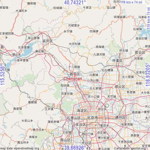
Chengnan GPS coordinates[2]
40° 12' 30.096" North, 116° 13' 44.112" East
| Map corner | latitude | longitude |
|---|---|---|
| Upper-left | 40.74321°, | 115.5258° |
| Center: | 40.20836°, | 116.22892° |
| Lower-right: | 39.66926°, | 116.93205° |
| Map W x H: | 119.4×119.4 km | = 74.2×74.2mi |
| max Lat: | 53.31946° ⇑12.8% North |
| Chengnan: | 40.20836° |
| min Lat: | ⇓87.2% South 18.22056° |
| min Long | Chengnan | max Long |
| 75.07348° | 116.22892° | 134.28917° |
| W 61.4%⇐ | ⇒38.6% E |
Elevation
Elevation of Chengnan is 66 m = 217 ft, and this is 418.8 m = 1374 ft below average elevation for this country.
| Max E: |
5622 m = 18445 ft | 66.6% |
| Avg. | 484.8 m = 1591 ft | |
| Chengnan | 66 m = 217 ft | |
Min E: |
-3 m = -10 ft | 33.4% |
See also: China elevation on elevation.city.
Geographical zone
Chengnan is located in North temperate zone (between Tropic of Cancer and the Arctic Circle). Distance of this Northern Tropic circle is 1864.8 km =1158.7 mi to South.| Distance of | km | miles | from Chengnan |
|---|---|---|---|
| North Pole | 5536.3 | 3440.1 | to North |
| Arctic Circle | 2930.4 | 1820.9 | to North |
| Tropic Cancer | 1864.8 | 1158.7 | to South |
| Equator | 4470.8 | 2778 | to South |


Nearby cities:
15 places around Chengnan: (largest is in red/bold)
• Changling
9.8 km =6.1 mi,  9°
9°
• Changping
1 km =0.6 mi,  29°
29°
• Chengbei
2.2 km =1.4 mi,  41°
41°
• Cuicun
10.5 km =6.5 mi,  83°
83°
• Huilongguan
17.2 km =10.7 mi,  148°
148°
• Liucun
14.9 km =9.3 mi,  253°
253°
• Machikou
6.4 km =4 mi,  243°
243°
• Nankou
9.4 km =5.8 mi,  289°
289°
• Nanshao
4.3 km =2.7 mi,  93°
93°
• Shahe
9.8 km =6.1 mi,  164°
164°
• Shisanling
6.9 km =4.3 mi,  357°
357°
• Sujiatuo
15.8 km =9.8 mi,  202°
202°
• Xiaotangshan
13.7 km =8.5 mi,  104°
104°
• Xingshou
15.1 km =9.4 mi, 85°
• Yangfang
11.5 km =7.1 mi,  227°
227°
Sources, notices
• [Note1] Compared only with cities in China existing in our database
• [Src1] Map data: © OpenStreetMap contributors (CC-BY-SA)
• [Src2] Other city data from geonames.org with taken over terms of usage.
• [Src3] Geographical zone / Annual Mean Temperature by Robert A. Rohde @ Wikipedia
