Longfeng geodata
Longfeng (Heilongjiang) is a seat of a third-order administrative division; located in China in Asia/Shanghai (GMT+8) time zone. With population of 152,074 people, there are 294 cities with bigger population in this country. Compared to other cities in China, 95.9% of cities are located further ↓South; 94.8% of cities are located further ←West and 52.4% of cities have higher elevation than Longfeng. Note1


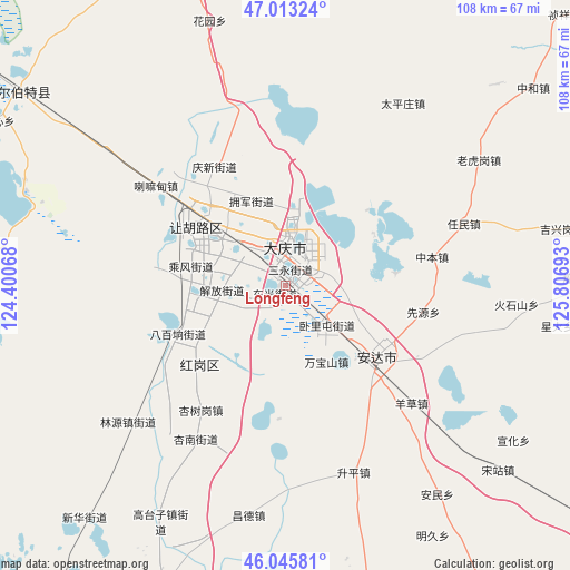
Longfeng GPS coordinates[2]
46° 31' 54.048" North, 125° 6' 13.68" East
| Map corner | latitude | longitude |
|---|---|---|
| Upper-left | 47.01324°, | 124.40068° |
| Center: | 46.53168°, | 125.1038° |
| Lower-right: | 46.04581°, | 125.80693° |
| Map W x H: | 107.6×107.6 km | = 66.9×66.9mi |
| max Lat: | 53.31946° ⇑4.1% North |
| Longfeng: | 46.53168° |
| min Lat: | ⇓95.9% South 18.22056° |
| min Long | Longfeng | max Long |
| 75.07348° | 125.1038° | 134.28917° |
| W 94.8%⇐ | ⇒5.2% E |
Elevation
Elevation of Longfeng is 147 m = 482 ft, and this is 337.8 m = 1108 ft below average elevation for this country.
| Max E: |
5622 m = 18445 ft | 52.4% |
| Avg. | 484.8 m = 1591 ft | |
| Longfeng | 147 m = 482 ft | |
Min E: |
-3 m = -10 ft | 47.6% |
See also: Longfeng elevation on elevation.city.
Geographical zone
Longfeng is located in North temperate zone (between Tropic of Cancer and the Arctic Circle). Distance of this North polar circle is 2227.3 km =1384 mi to North.| Distance of | km | miles | from Longfeng |
|---|---|---|---|
| North Pole | 4833.2 | 3003.2 | to North |
| Arctic Circle | 2227.3 | 1384 | to North |
| Tropic Cancer | 2567.9 | 1595.6 | to South |
| Equator | 5173.8 | 3214.8 | to South |


Nearby cities:
15 places around Longfeng: (largest is in red/bold)
• Anda
21.6 km =13.4 mi,  131°
131°
• Daqing
9.8 km =6.1 mi,  305°
305°
• Dong’an
7.2 km =4.5 mi,  344°
344°
• Fendou
22.1 km =13.7 mi,  303°
303°
• Honggang
22.3 km =13.9 mi,  229°
229°
• Lamadian
30.7 km =19.1 mi, 306°
• Qingkenpao
29.2 km =18.1 mi,  117°
117°
• Renmin
35.4 km =22 mi,  71°
71°
• Shengping
37.4 km =23.2 mi,  160°
160°
• Wanbaoshan
17.3 km =10.7 mi,  153°
153°
• Wolitun
15.7 km =9.8 mi, 116°
• Xianyuan
26.6 km =16.5 mi,  100°
100°
• Xingshugang
28.6 km =17.8 mi,  214°
214°
• Yangcao
32.6 km =20.3 mi, 132°
• Zhongben
28.2 km =17.5 mi,  78°
78°
Sources, notices
• [Note1] Compared only with cities in China existing in our database
• [Src1] Map data: © OpenStreetMap contributors (CC-BY-SA)
• [Src2] Other city data from geonames.org with taken over terms of usage.
• [Src3] Geographical zone / Annual Mean Temperature by Robert A. Rohde @ Wikipedia
