Xianyuan geodata
Xianyuan (Heilongjiang) is a seat of a fourth-order administrative division; located in China in Asia/Shanghai (GMT+8) time zone. In our database, there are 1268 cities with bigger population. Compared to other cities in China, 95.9% of cities are located further ↓South; 95% of cities are located further ←West and 51.8% of cities have higher elevation than Xianyuan. Note1


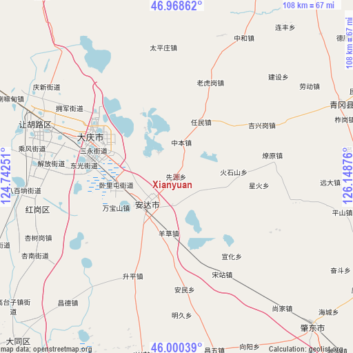
Xianyuan GPS coordinates[2]
46° 29' 11.976" North, 125° 26' 44.268" East
| Map corner | latitude | longitude |
|---|---|---|
| Upper-left | 46.96862°, | 124.74251° |
| Center: | 46.48666°, | 125.44563° |
| Lower-right: | 46.00039°, | 126.14876° |
| Map W x H: | 107.7×107.7 km | = 66.9×66.9mi |
| max Lat: | 53.31946° ⇑4.1% North |
| Xianyuan: | 46.48666° |
| min Lat: | ⇓95.9% South 18.22056° |
| min Long | Xianyuan | max Long |
| 75.07348° | 125.44563° | 134.28917° |
| W 95%⇐ | ⇒5% E |
Elevation
Elevation of Xianyuan is 151 m = 495 ft, and this is 333.8 m = 1095 ft below average elevation for this country.
| Max E: |
5622 m = 18445 ft | 51.8% |
| Avg. | 484.8 m = 1591 ft | |
| Xianyuan | 151 m = 495 ft | |
Min E: |
-3 m = -10 ft | 48.2% |
See also: China elevation on elevation.city.
Geographical zone
Xianyuan is located in North temperate zone (between Tropic of Cancer and the Arctic Circle). Distance of this North polar circle is 2232.3 km =1387.1 mi to North.| Distance of | km | miles | from Xianyuan |
|---|---|---|---|
| North Pole | 4838.2 | 3006.3 | to North |
| Arctic Circle | 2232.3 | 1387.1 | to North |
| Tropic Cancer | 2562.9 | 1592.5 | to South |
| Equator | 5168.8 | 3211.7 | to South |


Nearby cities:
15 places around Xianyuan: (largest is in red/bold)
• Anda
13.8 km =8.6 mi,  226°
226°
• Dong’an
30.5 km =19 mi,  293°
293°
• Huoshishan
17.6 km =10.9 mi,  85°
85°
• Jixinggang
30.4 km =18.9 mi,  59°
59°
• Laohugang
30.5 km =19 mi,  19°
19°
• Liaoyuan
30 km =18.6 mi,  77°
77°
• Longfeng
26.6 km =16.5 mi,  280°
280°
• Qingkenpao
8.7 km =5.4 mi,  182°
182°
• Renmin
18.1 km =11.2 mi, 24°
• Wanbaoshan
21.3 km =13.2 mi,  240°
240°
• Wolitun
12.3 km =7.6 mi,  260°
260°
• Xinghuo
25.1 km =15.6 mi,  95°
95°
• Xuanhua
29.4 km =18.3 mi,  145°
145°
• Yangcao
17.4 km =10.8 mi,  187°
187°
• Zhongben
10.6 km =6.6 mi,  8°
8°
Sources, notices
• [Note1] Compared only with cities in China existing in our database
• [Src1] Map data: © OpenStreetMap contributors (CC-BY-SA)
• [Src2] Other city data from geonames.org with taken over terms of usage.
• [Src3] Geographical zone / Annual Mean Temperature by Robert A. Rohde @ Wikipedia
