Lamadian geodata
Lamadian (Heilongjiang) is a seat of a fourth-order administrative division; located in China in Asia/Shanghai (GMT+8) time zone. In our database, there are 1268 cities with bigger population. Compared to other cities in China, 96.3% of cities are located further ↓South; 94.5% of cities are located further ←West and 53.2% of cities have higher elevation than Lamadian. Note1


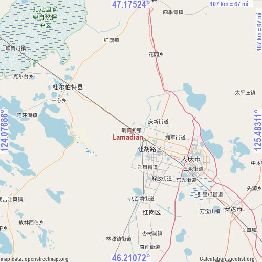
Lamadian GPS coordinates[2]
46° 41' 42.468" North, 124° 46' 47.928" East
| Map corner | latitude | longitude |
|---|---|---|
| Upper-left | 47.17524°, | 124.07686° |
| Center: | 46.69513°, | 124.77998° |
| Lower-right: | 46.21072°, | 125.48311° |
| Map W x H: | 107.2×107.2 km | = 66.6×66.6mi |
| max Lat: | 53.31946° ⇑3.7% North |
| Lamadian: | 46.69513° |
| min Lat: | ⇓96.3% South 18.22056° |
| min Long | Lamadian | max Long |
| 75.07348° | 124.77998° | 134.28917° |
| W 94.5%⇐ | ⇒5.5% E |
Elevation
Elevation of Lamadian is 142 m = 466 ft, and this is 342.8 m = 1125 ft below average elevation for this country.
| Max E: |
5622 m = 18445 ft | 53.2% |
| Avg. | 484.8 m = 1591 ft | |
| Lamadian | 142 m = 466 ft | |
Min E: |
-3 m = -10 ft | 46.8% |
See also: China elevation on elevation.city.
Geographical zone
Lamadian is located in North temperate zone (between Tropic of Cancer and the Arctic Circle). Distance of this North polar circle is 2209.2 km =1372.7 mi to North.| Distance of | km | miles | from Lamadian |
|---|---|---|---|
| North Pole | 4815.1 | 2992 | to North |
| Arctic Circle | 2209.2 | 1372.7 | to North |
| Tropic Cancer | 2586.1 | 1606.9 | to South |
| Equator | 5192 | 3226.2 | to South |


Nearby cities:
15 places around Lamadian: (largest is in red/bold)
• Baiyinnuole
43.1 km =26.8 mi,  279°
279°
• Daqing
20.9 km =13 mi,  126°
126°
• Dong’an
25.4 km =15.8 mi,  116°
116°
• Fendou
8.7 km =5.4 mi, 133°
• Honggang
33.6 km =20.9 mi,  166°
166°
• Hongqi
38.3 km =23.8 mi,  347°
347°
• Huayuan
32.9 km =20.4 mi,  17°
17°
• Linyuan
43.5 km =27 mi,  187°
187°
• Longfeng
30.7 km =19.1 mi, 126°
• Taikang
31.7 km =19.7 mi,  305°
305°
• Taipingzhuang
49.3 km =30.6 mi,  71°
71°
• Wanbaoshan
46.7 km =29 mi,  136°
136°
• Wolitun
46.3 km =28.8 mi, 123°
• Xingshugang
42.6 km =26.5 mi, 168°
• Yixin
32.2 km =20 mi,  293°
293°
Sources, notices
• [Note1] Compared only with cities in China existing in our database
• [Src1] Map data: © OpenStreetMap contributors (CC-BY-SA)
• [Src2] Other city data from geonames.org with taken over terms of usage.
• [Src3] Geographical zone / Annual Mean Temperature by Robert A. Rohde @ Wikipedia
