Daqing geodata
Daqing (Heilongjiang) is a populated place; located in China in Asia/Shanghai (GMT+8) time zone. With population of 203,488 people, there are 227 cities with bigger population in this country. Compared to other cities in China, 96% of cities are located further ↓South; 94.7% of cities are located further ←West and 52.6% of cities have higher elevation than Daqing. Note1


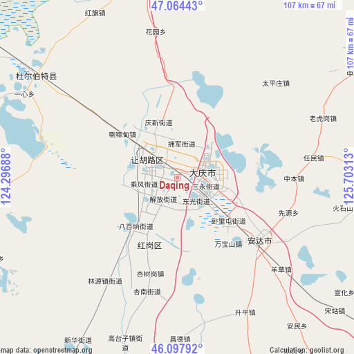
Daqing GPS coordinates[2]
46° 34' 59.988" North, 125° 0' 0" East
| Map corner | latitude | longitude |
|---|---|---|
| Upper-left | 47.06443°, | 124.29688° |
| Center: | 46.58333°, | 125° |
| Lower-right: | 46.09792°, | 125.70313° |
| Map W x H: | 107.5×107.5 km | = 66.8×66.8mi |
| max Lat: | 53.31946° ⇑4% North |
| Daqing: | 46.58333° |
| min Lat: | ⇓96% South 18.22056° |
| min Long | Daqing | max Long |
| 75.07348° | 125° | 134.28917° |
| W 94.7%⇐ | ⇒5.3% E |
Elevation
Elevation of Daqing is 146 m = 479 ft, and this is 338.8 m = 1112 ft below average elevation for this country.
| Max E: |
5622 m = 18445 ft | 52.6% |
| Avg. | 484.8 m = 1591 ft | |
| Daqing | 146 m = 479 ft | |
Min E: |
-3 m = -10 ft | 47.4% |
See also: Daqing elevation on elevation.city.
Geographical zone
Daqing is located in North temperate zone (between Tropic of Cancer and the Arctic Circle). Distance of this North polar circle is 2221.6 km =1380.4 mi to North.| Distance of | km | miles | from Daqing |
|---|---|---|---|
| North Pole | 4827.5 | 2999.7 | to North |
| Arctic Circle | 2221.6 | 1380.4 | to North |
| Tropic Cancer | 2573.7 | 1599.2 | to South |
| Equator | 5179.6 | 3218.5 | to South |


Nearby cities:
15 places around Daqing: (largest is in red/bold)
• Anda
31.4 km =19.5 mi,  129°
129°
• Dong’an
6.1 km =3.8 mi,  78°
78°
• Fendou
12.3 km =7.6 mi,  301°
301°
• Honggang
22.1 km =13.7 mi,  203°
203°
• Lamadian
20.9 km =13 mi,  306°
306°
• Linyuan
38 km =23.6 mi,  216°
216°
• Longfeng
9.8 km =6.1 mi, 125°
• Qingkenpao
39 km =24.2 mi,  119°
119°
• Renmin
41.8 km =26 mi, 82°
• Taipingzhuang
41.2 km =25.6 mi,  46°
46°
• Wanbaoshan
26.3 km =16.3 mi,  143°
143°
• Wolitun
25.5 km =15.8 mi, 120°
• Xianyuan
35.7 km =22.2 mi,  107°
107°
• Xingshugang
30.5 km =19 mi, 195°
• Zhongben
35.6 km =22.1 mi,  90°
90°
Sources, notices
• [Note1] Compared only with cities in China existing in our database
• [Src1] Map data: © OpenStreetMap contributors (CC-BY-SA)
• [Src2] Other city data from geonames.org with taken over terms of usage.
• [Src3] Geographical zone / Annual Mean Temperature by Robert A. Rohde @ Wikipedia
