Anda geodata
Anda (Heilongjiang) is a seat of a third-order administrative division; located in China in Asia/Shanghai (GMT+8) time zone. With population of 181,271 people, there are 247 cities with bigger population in this country. Compared to other cities in China, 95.7% of cities are located further ↓South; 94.9% of cities are located further ←West and 52.2% of cities have higher elevation than Anda. Note1


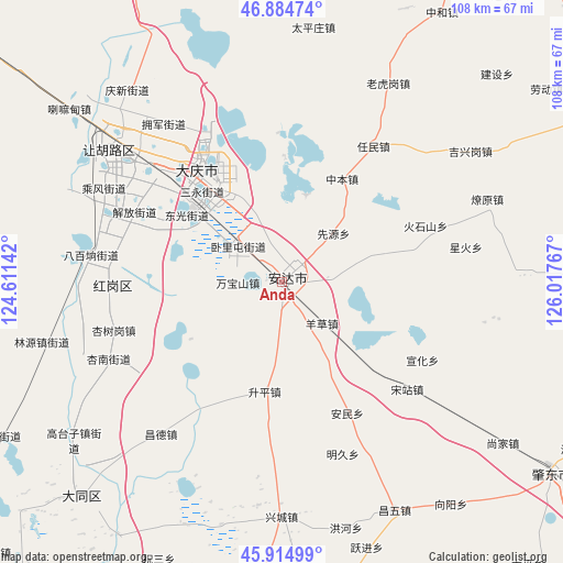
Anda GPS coordinates[2]
46° 24' 7.272" North, 125° 18' 52.344" East
| Map corner | latitude | longitude |
|---|---|---|
| Upper-left | 46.88474°, | 124.61142° |
| Center: | 46.40202°, | 125.31454° |
| Lower-right: | 45.91499°, | 126.01767° |
| Map W x H: | 107.8×107.8 km | = 67×67mi |
| max Lat: | 53.31946° ⇑4.3% North |
| Anda: | 46.40202° |
| min Lat: | ⇓95.7% South 18.22056° |
| min Long | Anda | max Long |
| 75.07348° | 125.31454° | 134.28917° |
| W 94.9%⇐ | ⇒5.1% E |
Elevation
Elevation of Anda is 148 m = 486 ft, and this is 336.8 m = 1105 ft below average elevation for this country.
| Max E: |
5622 m = 18445 ft | 52.2% |
| Avg. | 484.8 m = 1591 ft | |
| Anda | 148 m = 486 ft | |
Min E: |
-3 m = -10 ft | 47.8% |
See also: Anda elevation on elevation.city.
Geographical zone
Anda is located in North temperate zone (between Tropic of Cancer and the Arctic Circle). Distance of this North polar circle is 2241.8 km =1393 mi to North.| Distance of | km | miles | from Anda |
|---|---|---|---|
| North Pole | 4847.6 | 3012.2 | to North |
| Arctic Circle | 2241.8 | 1393 | to North |
| Tropic Cancer | 2553.5 | 1586.7 | to South |
| Equator | 5159.4 | 3205.9 | to South |


Nearby cities:
15 places around Anda: (largest is in red/bold)
• Anmin
28 km =17.4 mi,  153°
153°
• Daqing
31.4 km =19.5 mi,  309°
309°
• Dong’an
28 km =17.4 mi,  319°
319°
• Huoshishan
29.7 km =18.5 mi,  68°
68°
• Longfeng
21.6 km =13.4 mi, 311°
• Qingkenpao
9.7 km =6 mi,  85°
85°
• Renmin
31.2 km =19.4 mi,  33°
33°
• Shengping
21.2 km =13.2 mi,  189°
189°
• Songzhan
31.2 km =19.4 mi,  130°
130°
• Wanbaoshan
8.5 km =5.3 mi,  262°
262°
• Wolitun
7.6 km =4.7 mi,  344°
344°
• Xianyuan
13.8 km =8.6 mi,  46°
46°
• Xuanhua
30.6 km =19 mi,  118°
118°
• Yangcao
11 km =6.8 mi,  135°
135°
• Zhongben
23 km =14.3 mi, 30°
Sources, notices
• [Note1] Compared only with cities in China existing in our database
• [Src1] Map data: © OpenStreetMap contributors (CC-BY-SA)
• [Src2] Other city data from geonames.org with taken over terms of usage.
• [Src3] Geographical zone / Annual Mean Temperature by Robert A. Rohde @ Wikipedia
