Liaozhong geodata
Liaozhong (Liaoning) is a populated place; located in China in Asia/Shanghai (GMT+8) time zone. With population of 54,691 people, there are 795 cities with bigger population in this country. Compared to other cities in China, 90.1% of cities are located further ↓South; 92.4% of cities are located further ←West and 84.9% of cities have higher elevation than Liaozhong. Note1


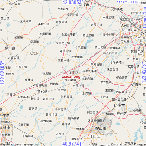
Liaozhong GPS coordinates[2]
41° 30' 21.996" North, 122° 43' 27.012" East
| Map corner | latitude | longitude |
|---|---|---|
| Upper-left | 42.03053°, | 122.02105° |
| Center: | 41.50611°, | 122.72417° |
| Lower-right: | 40.97741°, | 123.4273° |
| Map W x H: | 117.1×117.1 km | = 72.8×72.8mi |
| max Lat: | 53.31946° ⇑9.9% North |
| Liaozhong: | 41.50611° |
| min Lat: | ⇓90.1% South 18.22056° |
| min Long | Liaozhong | max Long |
| 75.07348° | 122.72417° | 134.28917° |
| W 92.4%⇐ | ⇒7.6% E |
Elevation
Elevation of Liaozhong is 16 m = 52 ft, and this is 468.8 m = 1538 ft below average elevation for this country.
| Max E: |
5622 m = 18445 ft | 84.9% |
| Avg. | 484.8 m = 1591 ft | |
| Liaozhong | 16 m = 52 ft | |
Min E: |
-3 m = -10 ft | 15.1% |
See also: Liaozhong elevation on elevation.city.
Geographical zone
Liaozhong is located in North temperate zone (between Tropic of Cancer and the Arctic Circle). Distance of this Northern Tropic circle is 2009.1 km =1248.4 mi to South.| Distance of | km | miles | from Liaozhong |
|---|---|---|---|
| North Pole | 5392 | 3350.4 | to North |
| Arctic Circle | 2786.1 | 1731.2 | to North |
| Tropic Cancer | 2009.1 | 1248.4 | to South |
| Equator | 4615 | 2867.6 | to South |


Nearby cities:
15 places around Liaozhong: (largest is in red/bold)
• Anshan
48 km =29.8 mi,  152°
152°
• Dalian
49.7 km =30.9 mi,  192°
192°
• Datun
59.1 km =36.7 mi,  164°
164°
• Fu’an
48.8 km =30.3 mi,  169°
169°
• Gaoshanzi
56.4 km =35 mi,  274°
274°
• Gaotuo
41.7 km =25.9 mi, 187°
• Gengzhuang
57.9 km =36 mi,  181°
181°
• Heishan
54.8 km =34.1 mi,  291°
291°
• Jiupu
52.4 km =32.6 mi, 158°
• Liaoyang
45.6 km =28.3 mi,  124°
124°
• Liujia
50.9 km =31.6 mi, 269°
• Sujiatun
53.9 km =33.5 mi,  71°
71°
• Wangtai
58.8 km =36.5 mi, 189°
• Wujia
60.7 km =37.7 mi, 265°
• Xinmin
54.5 km =33.9 mi,  8°
8°
Sources, notices
• [Note1] Compared only with cities in China existing in our database
• [Src1] Map data: © OpenStreetMap contributors (CC-BY-SA)
• [Src2] Other city data from geonames.org with taken over terms of usage.
• [Src3] Geographical zone / Annual Mean Temperature by Robert A. Rohde @ Wikipedia
