Liaoyang geodata
Liaoyang (Liaoning) is a populated place; located in China in Asia/Shanghai (GMT+8) time zone. With population of 687,890 people, there are 93 cities with bigger population in this country. Compared to other cities in China, 89.7% of cities are located further ↓South; 92.8% of cities are located further ←West and 76.7% of cities have higher elevation than Liaoyang. Note1


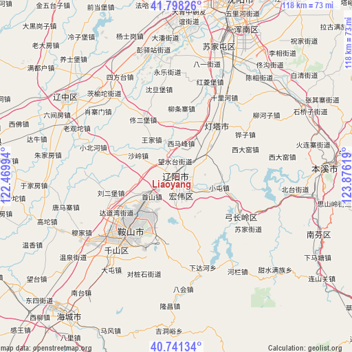
Liaoyang GPS coordinates[2]
41° 16' 18.984" North, 123° 10' 23.016" East
| Map corner | latitude | longitude |
|---|---|---|
| Upper-left | 41.79826°, | 122.46994° |
| Center: | 41.27194°, | 123.17306° |
| Lower-right: | 40.74134°, | 123.87619° |
| Map W x H: | 117.5×117.5 km | = 73×73mi |
| max Lat: | 53.31946° ⇑10.3% North |
| Liaoyang: | 41.27194° |
| min Lat: | ⇓89.7% South 18.22056° |
| min Long | Liaoyang | max Long |
| 75.07348° | 123.17306° | 134.28917° |
| W 92.8%⇐ | ⇒7.2% E |
Elevation
Elevation of Liaoyang is 33 m = 108 ft, and this is 451.8 m = 1482 ft below average elevation for this country.
| Max E: |
5622 m = 18445 ft | 76.7% |
| Avg. | 484.8 m = 1591 ft | |
| Liaoyang | 33 m = 108 ft | |
Min E: |
-3 m = -10 ft | 23.3% |
See also: Liaoyang elevation on elevation.city.
Geographical zone
Liaoyang is located in North temperate zone (between Tropic of Cancer and the Arctic Circle). Distance of this Northern Tropic circle is 1983.1 km =1232.2 mi to South.| Distance of | km | miles | from Liaoyang |
|---|---|---|---|
| North Pole | 5418.1 | 3366.7 | to North |
| Arctic Circle | 2812.2 | 1747.4 | to North |
| Tropic Cancer | 1983.1 | 1232.2 | to South |
| Equator | 4589 | 2851.5 | to South |


Nearby cities:
15 places around Liaoyang: (largest is in red/bold)
• Anshan
22.5 km =14 mi,  222°
222°
• Bahui
37.9 km =23.5 mi,  176°
176°
• Benxi
49.5 km =30.8 mi,  87°
87°
• Datun
37.8 km =23.5 mi, 215°
• Fu’an
36.1 km =22.4 mi,  232°
232°
• Ganquan
43.4 km =27 mi, 217°
• Gaotuo
45.6 km =28.3 mi,  250°
250°
• Gengzhuang
50.7 km =31.5 mi, 231°
• Gongchangling
28.9 km =18 mi,  126°
126°
• Jiupu
29.5 km =18.3 mi, 219°
• Liaozhong
45.6 km =28.3 mi,  304°
304°
• Nantai
49.5 km =30.8 mi, 218°
• Shangmatun
39.9 km =24.8 mi,  156°
156°
• Sujiatun
45.2 km =28.1 mi,  17°
17°
• Xiadahe
31.6 km =19.6 mi, 164°
Sources, notices
• [Note1] Compared only with cities in China existing in our database
• [Src1] Map data: © OpenStreetMap contributors (CC-BY-SA)
• [Src2] Other city data from geonames.org with taken over terms of usage.
• [Src3] Geographical zone / Annual Mean Temperature by Robert A. Rohde @ Wikipedia
