Anshan geodata
Anshan (Liaoning) is a populated place; located in China in Asia/Shanghai (GMT+8) time zone. With population of 1,199,275 people, there are 55 cities with bigger population in this country. Compared to other cities in China, 89.4% of cities are located further ↓South; 92.7% of cities are located further ←West and 69.2% of cities have higher elevation than Anshan. Note1


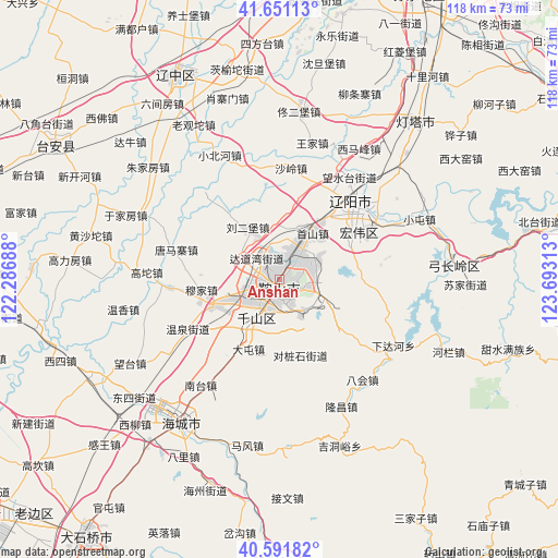
Anshan GPS coordinates[2]
41° 7' 24.996" North, 122° 59' 24" East
| Map corner | latitude | longitude |
|---|---|---|
| Upper-left | 41.65113°, | 122.28688° |
| Center: | 41.12361°, | 122.99° |
| Lower-right: | 40.59182°, | 123.69313° |
| Map W x H: | 117.8×117.8 km | = 73.2×73.2mi |
| max Lat: | 53.31946° ⇑10.6% North |
| Anshan: | 41.12361° |
| min Lat: | ⇓89.4% South 18.22056° |
| min Long | Anshan | max Long |
| 75.07348° | 122.99° | 134.28917° |
| W 92.7%⇐ | ⇒7.3% E |
Elevation
Elevation of Anshan is 55 m = 180 ft, and this is 429.8 m = 1410 ft below average elevation for this country.
| Max E: |
5622 m = 18445 ft | 69.2% |
| Avg. | 484.8 m = 1591 ft | |
| Anshan | 55 m = 180 ft | |
Min E: |
-3 m = -10 ft | 30.8% |
See also: Anshan elevation on elevation.city.
Geographical zone
Anshan is located in North temperate zone (between Tropic of Cancer and the Arctic Circle). Distance of this Northern Tropic circle is 1966.6 km =1222 mi to South.| Distance of | km | miles | from Anshan |
|---|---|---|---|
| North Pole | 5434.5 | 3376.8 | to North |
| Arctic Circle | 2828.7 | 1757.7 | to North |
| Tropic Cancer | 1966.6 | 1222 | to South |
| Equator | 4572.5 | 2841.2 | to South |


Nearby cities:
15 places around Anshan: (largest is in red/bold)
• Bahui
27.7 km =17.2 mi,  140°
140°
• Dalian
33.3 km =20.7 mi,  259°
259°
• Datun
15.8 km =9.8 mi,  204°
204°
• Fu’an
14.4 km =8.9 mi,  247°
247°
• Ganquan
21.1 km =13.1 mi,  212°
212°
• Gaotuo
27.7 km =17.2 mi,  272°
272°
• Gengzhuang
28.6 km =17.8 mi,  237°
237°
• Haicheng
36.5 km =22.7 mi, 213°
• Jiupu
7.2 km =4.5 mi, 207°
• Liaoyang
22.5 km =14 mi,  42°
42°
• Mafeng
35.6 km =22.1 mi,  190°
190°
• Nantai
27.1 km =16.8 mi,  215°
215°
• Wangshi
32.8 km =20.4 mi, 206°
• Wangtai
35.9 km =22.3 mi, 244°
• Xiadahe
27.7 km =17.2 mi,  120°
120°
Sources, notices
• [Note1] Compared only with cities in China existing in our database
• [Src1] Map data: © OpenStreetMap contributors (CC-BY-SA)
• [Src2] Other city data from geonames.org with taken over terms of usage.
• [Src3] Geographical zone / Annual Mean Temperature by Robert A. Rohde @ Wikipedia
