Jiupu geodata
Jiupu (Liaoning) is a populated place; located in China in Asia/Shanghai (GMT+8) time zone. With population of 123,843 people, there are 356 cities with bigger population in this country. Compared to other cities in China, 89.3% of cities are located further ↓South; 92.6% of cities are located further ←West and 77.7% of cities have higher elevation than Jiupu. Note1


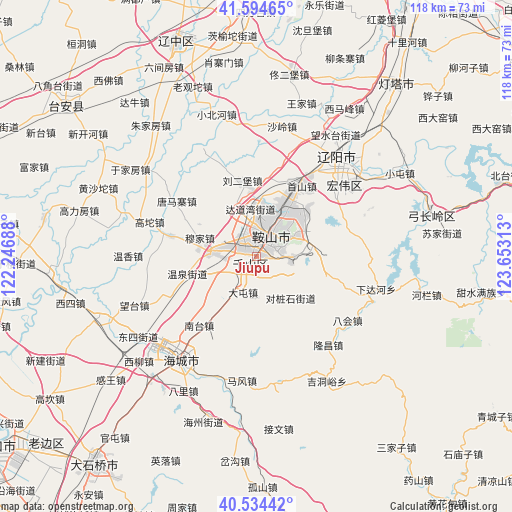
Jiupu GPS coordinates[2]
41° 4' 0.012" North, 122° 57' 0" East
| Map corner | latitude | longitude |
|---|---|---|
| Upper-left | 41.59465°, | 122.24688° |
| Center: | 41.06667°, | 122.95° |
| Lower-right: | 40.53442°, | 123.65313° |
| Map W x H: | 117.9×117.9 km | = 73.3×73.3mi |
| max Lat: | 53.31946° ⇑10.7% North |
| Jiupu: | 41.06667° |
| min Lat: | ⇓89.3% South 18.22056° |
| min Long | Jiupu | max Long |
| 75.07348° | 122.95° | 134.28917° |
| W 92.6%⇐ | ⇒7.4% E |
Elevation
Elevation of Jiupu is 31 m = 102 ft, and this is 453.8 m = 1489 ft below average elevation for this country.
| Max E: |
5622 m = 18445 ft | 77.7% |
| Avg. | 484.8 m = 1591 ft | |
| Jiupu | 31 m = 102 ft | |
Min E: |
-3 m = -10 ft | 22.3% |
See also: Jiupu elevation on elevation.city.
Geographical zone
Jiupu is located in North temperate zone (between Tropic of Cancer and the Arctic Circle). Distance of this Northern Tropic circle is 1960.3 km =1218.1 mi to South.| Distance of | km | miles | from Jiupu |
|---|---|---|---|
| North Pole | 5440.9 | 3380.8 | to North |
| Arctic Circle | 2835 | 1761.6 | to North |
| Tropic Cancer | 1960.3 | 1218.1 | to South |
| Equator | 4566.2 | 2837.3 | to South |


Nearby cities:
15 places around Jiupu: (largest is in red/bold)
• Anshan
7.2 km =4.5 mi,  27°
27°
• Bahui
25.8 km =16 mi,  125°
125°
• Dalian
29.5 km =18.3 mi,  270°
270°
• Datun
8.7 km =5.4 mi,  200°
200°
• Fu’an
10.1 km =6.3 mi,  275°
275°
• Ganquan
13.9 km =8.6 mi,  215°
215°
• Gaotuo
25.4 km =15.8 mi,  287°
287°
• Gengzhuang
22.7 km =14.1 mi,  246°
246°
• Haicheng
29.3 km =18.2 mi, 215°
• Liaoyang
29.5 km =18.3 mi,  39°
39°
• Mafeng
28.9 km =18 mi,  186°
186°
• Nantai
20 km =12.4 mi, 217°
• Wangshi
25.6 km =15.9 mi,  206°
206°
• Xiadahe
28.3 km =17.6 mi,  105°
105°
• Xinghai
29.4 km =18.3 mi, 219°
Sources, notices
• [Note1] Compared only with cities in China existing in our database
• [Src1] Map data: © OpenStreetMap contributors (CC-BY-SA)
• [Src2] Other city data from geonames.org with taken over terms of usage.
• [Src3] Geographical zone / Annual Mean Temperature by Robert A. Rohde @ Wikipedia
