Lianhua geodata
Lianhua (Heilongjiang) is a seat of a fourth-order administrative division; located in China in Asia/Shanghai (GMT+8) time zone. In our database, there are 1268 cities with bigger population. Compared to other cities in China, 94.4% of cities are located further ↓South; 99% of cities are located further ←West and 50.8% of cities have higher elevation than Lianhua. Note1


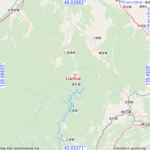
Lianhua GPS coordinates[2]
45° 31' 49.548" North, 129° 47' 22.812" East
| Map corner | latitude | longitude |
|---|---|---|
| Upper-left | 46.02083°, | 129.08655° |
| Center: | 45.53043°, | 129.78967° |
| Lower-right: | 45.03571°, | 130.4928° |
| Map W x H: | 109.5×109.5 km | = 68×68mi |
| max Lat: | 53.31946° ⇑5.6% North |
| Lianhua: | 45.53043° |
| min Lat: | ⇓94.4% South 18.22056° |
| min Long | Lianhua | max Long |
| 75.07348° | 129.78967° | 134.28917° |
| W 99%⇐ | ⇒1% E |
Elevation
Elevation of Lianhua is 158 m = 518 ft, and this is 326.8 m = 1072 ft below average elevation for this country.
| Max E: |
5622 m = 18445 ft | 50.8% |
| Avg. | 484.8 m = 1591 ft | |
| Lianhua | 158 m = 518 ft | |
Min E: |
-3 m = -10 ft | 49.2% |
See also: China elevation on elevation.city.
Geographical zone
Lianhua is located in North temperate zone (between Tropic of Cancer and the Arctic Circle). Distance of this North polar circle is 2338.7 km =1453.2 mi to North.| Distance of | km | miles | from Lianhua |
|---|---|---|---|
| North Pole | 4944.6 | 3072.4 | to North |
| Arctic Circle | 2338.7 | 1453.2 | to North |
| Tropic Cancer | 2456.6 | 1526.5 | to South |
| Equator | 5062.5 | 3145.7 | to South |


Nearby cities:
15 places around Lianhua: (largest is in red/bold)
• Boli
65.7 km =40.8 mi,  67°
67°
• Daluomi
65.6 km =40.8 mi,  316°
316°
• Dasizhan
61.3 km =38.1 mi,  53°
53°
• Diaoling
31.7 km =19.7 mi,  29°
29°
• Erdaohezi
47.1 km =29.3 mi,  184°
184°
• Gucheng
43.4 km =27 mi,  117°
117°
• Jiantang
25.8 km =16 mi, 50°
• Kuishan
58.1 km =36.1 mi,  125°
125°
• Linkou
45.8 km =28.5 mi, 126°
• Longzhua
41.8 km =26 mi,  138°
138°
• Sandaohezi
25.4 km =15.8 mi, 183°
• Sandaotong
17.2 km =10.7 mi,  345°
345°
• Shuanghe
62.5 km =38.8 mi,  37°
37°
• Yahe
52 km =32.3 mi,  106°
106°
• Yongheng
63.9 km =39.7 mi, 27°
Sources, notices
• [Note1] Compared only with cities in China existing in our database
• [Src1] Map data: © OpenStreetMap contributors (CC-BY-SA)
• [Src2] Other city data from geonames.org with taken over terms of usage.
• [Src3] Geographical zone / Annual Mean Temperature by Robert A. Rohde @ Wikipedia
