Linkou geodata
Linkou (Heilongjiang) is a seat of a third-order administrative division; located in China in Asia/Shanghai (GMT+8) time zone. With population of 77,754 people, there are 547 cities with bigger population in this country. Compared to other cities in China, 94.1% of cities are located further ↓South; 99.3% of cities are located further ←West and 61.2% of cities have lower elevation than Linkou. Note1


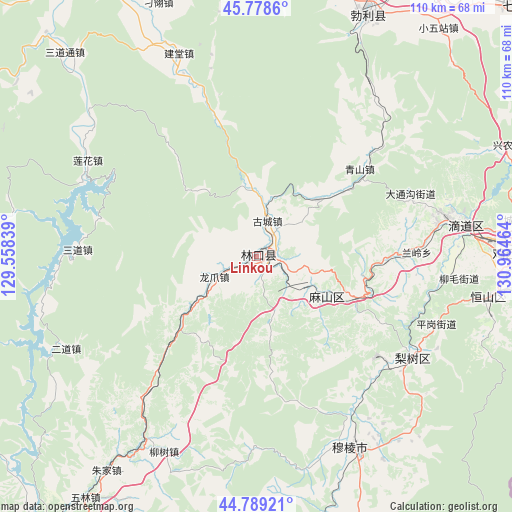
Linkou GPS coordinates[2]
45° 17' 9.816" North, 130° 15' 41.436" East
| Map corner | latitude | longitude |
|---|---|---|
| Upper-left | 45.7786°, | 129.55839° |
| Center: | 45.28606°, | 130.26151° |
| Lower-right: | 44.78921°, | 130.96464° |
| Map W x H: | 110×110 km | = 68.4×68.4mi |
| max Lat: | 53.31946° ⇑5.9% North |
| Linkou: | 45.28606° |
| min Lat: | ⇓94.1% South 18.22056° |
| min Long | Linkou | max Long |
| 75.07348° | 130.26151° | 134.28917° |
| W 99.3%⇐ | ⇒0.7% E |
Elevation
Elevation of Linkou is 274 m = 899 ft, and this is 210.8 m = 692 ft below average elevation for this country.
| Max E: |
5622 m = 18445 ft | 38.8% |
| Avg. | 484.8 m = 1591 ft | |
| Linkou | 274 m = 899 ft | |
Min E: |
-3 m = -10 ft | 61.2% |
See also: Linkou elevation on elevation.city.
Geographical zone
Linkou is located in North temperate zone (between Tropic of Cancer and the Arctic Circle). Distance of this North polar circle is 2365.8 km =1470 mi to North.| Distance of | km | miles | from Linkou |
|---|---|---|---|
| North Pole | 4971.7 | 3089.3 | to North |
| Arctic Circle | 2365.8 | 1470 | to North |
| Tropic Cancer | 2429.4 | 1509.6 | to South |
| Equator | 5035.3 | 3128.8 | to South |


Nearby cities:
15 places around Linkou: (largest is in red/bold)
• Bamiantong
45.7 km =28.4 mi,  153°
153°
• Didaohe
46 km =28.6 mi,  81°
81°
• Dongxing
41.9 km =26 mi, 78°
• Erdaohezi
45.5 km =28.3 mi,  244°
244°
• Fulu
46.3 km =28.8 mi, 147°
• Gucheng
7.7 km =4.8 mi,  14°
14°
• Hexi
43.5 km =27 mi,  156°
156°
• Kuishan
12.4 km =7.7 mi,  121°
121°
• Lanling
34.4 km =21.4 mi,  88°
88°
• Lianhua
45.8 km =28.5 mi,  306°
306°
• Lishu
40.1 km =24.9 mi, 122°
• Longzhua
10.1 km =6.3 mi,  245°
245°
• Mashan
22.6 km =14 mi,  113°
113°
• Sandaohezi
38.4 km =23.9 mi,  272°
272°
• Yahe
17.8 km =11.1 mi,  46°
46°
Sources, notices
• [Note1] Compared only with cities in China existing in our database
• [Src1] Map data: © OpenStreetMap contributors (CC-BY-SA)
• [Src2] Other city data from geonames.org with taken over terms of usage.
• [Src3] Geographical zone / Annual Mean Temperature by Robert A. Rohde @ Wikipedia
