Huayuan geodata
Huayuan (Heilongjiang) is a seat of a fourth-order administrative division; located in China in Asia/Shanghai (GMT+8) time zone. In our database, there are 1268 cities with bigger population. Compared to other cities in China, 96.9% of cities are located further ↓South; 94.7% of cities are located further ←West and 51.9% of cities have higher elevation than Huayuan. Note1


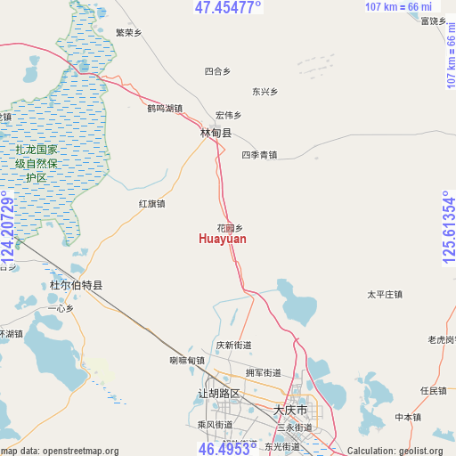
Huayuan GPS coordinates[2]
46° 58' 37.884" North, 124° 54' 37.476" East
| Map corner | latitude | longitude |
|---|---|---|
| Upper-left | 47.45477°, | 124.20729° |
| Center: | 46.97719°, | 124.91041° |
| Lower-right: | 46.4953°, | 125.61354° |
| Map W x H: | 106.7×106.7 km | = 66.3×66.3mi |
| max Lat: | 53.31946° ⇑3.1% North |
| Huayuan: | 46.97719° |
| min Lat: | ⇓96.9% South 18.22056° |
| min Long | Huayuan | max Long |
| 75.07348° | 124.91041° | 134.28917° |
| W 94.7%⇐ | ⇒5.3% E |
Elevation
Elevation of Huayuan is 150 m = 492 ft, and this is 334.8 m = 1098 ft below average elevation for this country.
| Max E: |
5622 m = 18445 ft | 51.9% |
| Avg. | 484.8 m = 1591 ft | |
| Huayuan | 150 m = 492 ft | |
Min E: |
-3 m = -10 ft | 48.1% |
See also: China elevation on elevation.city.
Geographical zone
Huayuan is located in North temperate zone (between Tropic of Cancer and the Arctic Circle). Distance of this North polar circle is 2177.8 km =1353.2 mi to North.| Distance of | km | miles | from Huayuan |
|---|---|---|---|
| North Pole | 4783.7 | 2972.5 | to North |
| Arctic Circle | 2177.8 | 1353.2 | to North |
| Tropic Cancer | 2617.5 | 1626.4 | to South |
| Equator | 5223.4 | 3245.7 | to South |


Nearby cities:
15 places around Huayuan: (largest is in red/bold)
• Daqing
44.3 km =27.5 mi,  171°
171°
• Dongxing
33.6 km =20.9 mi,  15°
15°
• Dong’an
44.5 km =27.7 mi,  163°
163°
• Fanrong
51.2 km =31.8 mi,  333°
333°
• Fendou
37.5 km =23.3 mi,  185°
185°
• Hongqi
19 km =11.8 mi,  288°
288°
• Hongwei
26.9 km =16.7 mi,  0°
0°
• Lamadian
32.9 km =20.4 mi,  197°
197°
• Liming
18.9 km =11.7 mi, 22°
• Lindian
23.1 km =14.4 mi,  351°
351°
• Sanhe
32 km =19.9 mi, 331°
• Sihe
36.9 km =22.9 mi,  355°
355°
• Taikang
37.8 km =23.5 mi,  250°
250°
• Taipingzhuang
39.7 km =24.7 mi,  112°
112°
• Yixin
43.5 km =27 mi,  244°
244°
Sources, notices
• [Note1] Compared only with cities in China existing in our database
• [Src1] Map data: © OpenStreetMap contributors (CC-BY-SA)
• [Src2] Other city data from geonames.org with taken over terms of usage.
• [Src3] Geographical zone / Annual Mean Temperature by Robert A. Rohde @ Wikipedia
