Kouquan geodata
Kouquan (Shanxi) is a seat of a third-order administrative division; located in China in Asia/Shanghai (GMT+8) time zone. In our database, there are 1268 cities with bigger population. Compared to other cities in China, 86.4% of cities are located further ↓South; 56.7% of cities are located further →East and 86.5% of cities have lower elevation than Kouquan. Note1


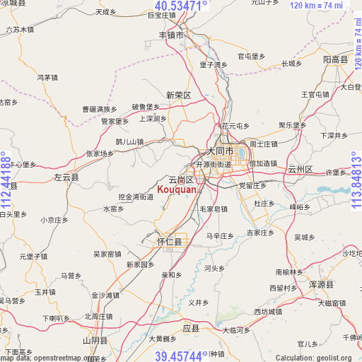
Kouquan GPS coordinates[2]
39° 59' 53.52" North, 113° 8' 42" East
| Map corner | latitude | longitude |
|---|---|---|
| Upper-left | 40.53471°, | 112.44188° |
| Center: | 39.9982°, | 113.145° |
| Lower-right: | 39.45744°, | 113.84813° |
| Map W x H: | 119.8×119.8 km | = 74.4×74.4mi |
| max Lat: | 53.31946° ⇑13.6% North |
| Kouquan: | 39.9982° |
| min Lat: | ⇓86.4% South 18.22056° |
| min Long | Kouquan | max Long |
| 75.07348° | 113.145° | 134.28917° |
| W 43.3%⇐ | ⇒56.7% E |
Elevation
Elevation of Kouquan is 1078 m = 3537 ft, and this is 593.2 m = 1946 ft above average elevation for this country.
| Max E: |
5622 m = 18445 ft | 13.5% |
| Kouquan | 1078 m 3537 ft | |
| Avg. | 484.8 m = 1591 ft | |
Min E: |
-3 m = -10 ft | 86.5% |
See also: China elevation on elevation.city.
Geographical zone
Kouquan is located in North temperate zone (between Tropic of Cancer and the Arctic Circle). Distance of this Northern Tropic circle is 1841.5 km =1144.3 mi to South.| Distance of | km | miles | from Kouquan |
|---|---|---|---|
| North Pole | 5559.7 | 3454.6 | to North |
| Arctic Circle | 2953.8 | 1835.4 | to North |
| Tropic Cancer | 1841.5 | 1144.3 | to South |
| Equator | 4447.4 | 2763.5 | to South |


Nearby cities:
15 places around Kouquan: (largest is in red/bold)
• Beijiazao
28.3 km =17.6 mi,  77°
77°
• Dangliuzhuang
23.6 km =14.7 mi,  92°
92°
• Datong
16.4 km =10.2 mi,  49°
49°
• Dianwan
23.8 km =14.8 mi,  266°
266°
• Duzhuang
28.3 km =17.6 mi,  104°
104°
• Haibeitou
21.9 km =13.6 mi,  171°
171°
• Hejiabao
22.1 km =13.7 mi,  201°
201°
• Majunying
12.3 km =7.6 mi,  33°
33°
• Maojiazao
13.8 km =8.6 mi,  129°
129°
• Que’ershan
21.8 km =13.5 mi,  308°
308°
• Shuiyao
24.8 km =15.4 mi,  245°
245°
• Xihanling
8.3 km =5.2 mi, 77°
• Ya’erya
13.3 km =8.3 mi,  255°
255°
• Yunzhong
19.5 km =12.1 mi,  192°
192°
• Zhangjiachang
28.3 km =17.6 mi,  289°
289°
Sources, notices
• [Note1] Compared only with cities in China existing in our database
• [Src1] Map data: © OpenStreetMap contributors (CC-BY-SA)
• [Src2] Other city data from geonames.org with taken over terms of usage.
• [Src3] Geographical zone / Annual Mean Temperature by Robert A. Rohde @ Wikipedia
