Ya’erya geodata
Ya’erya (Shanxi) is a seat of a fourth-order administrative division; located in China in Asia/Shanghai (GMT+8) time zone. In our database, there are 1268 cities with bigger population. Compared to other cities in China, 86.3% of cities are located further ↓South; 57.6% of cities are located further →East and 90.6% of cities have lower elevation than Ya’erya. Note1


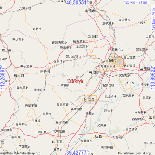
Ya’erya GPS coordinates[2]
39° 58' 7.536" North, 112° 59' 35.124" East
| Map corner | latitude | longitude |
|---|---|---|
| Upper-left | 40.50551°, | 112.28997° |
| Center: | 39.96876°, | 112.99309° |
| Lower-right: | 39.42777°, | 113.69622° |
| Map W x H: | 119.8×119.8 km | = 74.4×74.4mi |
| max Lat: | 53.31946° ⇑13.7% North |
| Ya’erya: | 39.96876° |
| min Lat: | ⇓86.3% South 18.22056° |
| min Long | Ya’erya | max Long |
| 75.07348° | 112.99309° | 134.28917° |
| W 42.4%⇐ | ⇒57.6% E |
Elevation
Elevation of Ya’erya is 1411 m = 4629 ft, and this is 926.2 m = 3039 ft above average elevation for this country.
| Max E: |
5622 m = 18445 ft | 9.4% |
| Ya’erya | 1411 m 4629 ft | |
| Avg. | 484.8 m = 1591 ft | |
Min E: |
-3 m = -10 ft | 90.6% |
See also: China elevation on elevation.city.
Geographical zone
Ya’erya is located in North temperate zone (between Tropic of Cancer and the Arctic Circle). Distance of this Northern Tropic circle is 1838.2 km =1142.2 mi to South.| Distance of | km | miles | from Ya’erya |
|---|---|---|---|
| North Pole | 5563 | 3456.7 | to North |
| Arctic Circle | 2957.1 | 1837.5 | to North |
| Tropic Cancer | 1838.2 | 1142.2 | to South |
| Equator | 4444.1 | 2761.4 | to South |


Nearby cities:
15 places around Ya’erya: (largest is in red/bold)
• Dianwan
11.1 km =6.9 mi,  280°
280°
• Guanjiabao
25.2 km =15.7 mi,  338°
338°
• Haibeitou
24.6 km =15.3 mi,  138°
138°
• Hejiabao
17.9 km =11.1 mi,  164°
164°
• Kouquan
13.3 km =8.3 mi,  75°
75°
• Madaotou
21.7 km =13.5 mi,  241°
241°
• Majunying
23.9 km =14.9 mi,  55°
55°
• Maojiazao
24.2 km =15 mi,  103°
103°
• Que’ershan
17.2 km =10.7 mi,  345°
345°
• Shuiyao
11.8 km =7.3 mi,  234°
234°
• Wujiayao
23.6 km =14.7 mi,  209°
209°
• Xihanling
21.6 km =13.4 mi, 76°
• Xinjiayuan
24 km =14.9 mi,  181°
181°
• Yunzhong
18 km =11.2 mi,  150°
150°
• Zhangjiachang
18.8 km =11.7 mi,  312°
312°
Sources, notices
• [Note1] Compared only with cities in China existing in our database
• [Src1] Map data: © OpenStreetMap contributors (CC-BY-SA)
• [Src2] Other city data from geonames.org with taken over terms of usage.
• [Src3] Geographical zone / Annual Mean Temperature by Robert A. Rohde @ Wikipedia
