Datong geodata
Datong (Shanxi) is a populated place; located in China in Asia/Shanghai (GMT+8) time zone. With population of 1,052,678 people, there are 60 cities with bigger population in this country. Compared to other cities in China, 86.7% of cities are located further ↓South; 55.7% of cities are located further →East and 86.2% of cities have lower elevation than Datong. Note1


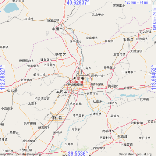
Datong GPS coordinates[2]
40° 5' 36.996" North, 113° 17' 29.004" East
| Map corner | latitude | longitude |
|---|---|---|
| Upper-left | 40.62937°, | 112.58827° |
| Center: | 40.09361°, | 113.29139° |
| Lower-right: | 39.5536°, | 113.99452° |
| Map W x H: | 119.6×119.6 km | = 74.3×74.3mi |
| max Lat: | 53.31946° ⇑13.3% North |
| Datong: | 40.09361° |
| min Lat: | ⇓86.7% South 18.22056° |
| min Long | Datong | max Long |
| 75.07348° | 113.29139° | 134.28917° |
| W 44.3%⇐ | ⇒55.7% E |
Elevation
Elevation of Datong is 1054 m = 3458 ft, and this is 569.2 m = 1867 ft above average elevation for this country.
| Max E: |
5622 m = 18445 ft | 13.8% |
| Datong | 1054 m 3458 ft | |
| Avg. | 484.8 m = 1591 ft | |
Min E: |
-3 m = -10 ft | 86.2% |
See also: Datong elevation on elevation.city.
Geographical zone
Datong is located in North temperate zone (between Tropic of Cancer and the Arctic Circle). Distance of this Northern Tropic circle is 1852.1 km =1150.8 mi to South.| Distance of | km | miles | from Datong |
|---|---|---|---|
| North Pole | 5549.1 | 3448 | to North |
| Arctic Circle | 2943.2 | 1828.8 | to North |
| Tropic Cancer | 1852.1 | 1150.8 | to South |
| Equator | 4458 | 2770.1 | to South |


Nearby cities:
15 places around Datong: (largest is in red/bold)
• Beijiazao
15.8 km =9.8 mi,  106°
106°
• Dangliuzhuang
16.1 km =10 mi,  136°
136°
• Duzhuang
23.1 km =14.4 mi, 139°
• Guayuan
31.8 km =19.8 mi,  104°
104°
• Jijiazhuang
30.5 km =19 mi,  152°
152°
• Jule
25.4 km =15.8 mi,  71°
71°
• Kouquan
16.4 km =10.2 mi,  229°
229°
• Majunying
5.7 km =3.5 mi,  266°
266°
• Maojiazao
19.5 km =12.1 mi,  185°
185°
• Que’ershan
29.7 km =18.5 mi,  275°
275°
• Xihanling
9.8 km =6.1 mi,  206°
206°
• Xinrong
22.5 km =14 mi,  324°
324°
• Xiping
27.3 km =17 mi, 102°
• Ya’erya
28.9 km =18 mi,  241°
241°
• Zhoushizhuang
15 km =9.3 mi,  81°
81°
Sources, notices
• [Note1] Compared only with cities in China existing in our database
• [Src1] Map data: © OpenStreetMap contributors (CC-BY-SA)
• [Src2] Other city data from geonames.org with taken over terms of usage.
• [Src3] Geographical zone / Annual Mean Temperature by Robert A. Rohde @ Wikipedia
