Zhangjiachang geodata
Zhangjiachang (Shanxi) is a seat of a fourth-order administrative division; located in China in Asia/Shanghai (GMT+8) time zone. In our database, there are 1268 cities with bigger population. Compared to other cities in China, 86.7% of cities are located further ↓South; 58.5% of cities are located further →East and 88.7% of cities have lower elevation than Zhangjiachang. Note1


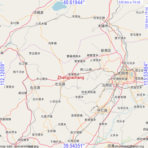
Zhangjiachang GPS coordinates[2]
40° 5' 0.96" North, 112° 49' 54.156" East
| Map corner | latitude | longitude |
|---|---|---|
| Upper-left | 40.61944°, | 112.12859° |
| Center: | 40.0836°, | 112.83171° |
| Lower-right: | 39.54351°, | 113.53484° |
| Map W x H: | 119.6×119.6 km | = 74.3×74.3mi |
| max Lat: | 53.31946° ⇑13.3% North |
| Zhangjiachang: | 40.0836° |
| min Lat: | ⇓86.7% South 18.22056° |
| min Long | Zhangjiachang | max Long |
| 75.07348° | 112.83171° | 134.28917° |
| W 41.5%⇐ | ⇒58.5% E |
Elevation
Elevation of Zhangjiachang is 1245 m = 4085 ft, and this is 760.2 m = 2494 ft above average elevation for this country.
| Max E: |
5622 m = 18445 ft | 11.3% |
| Zhangjiachang | 1245 m 4085 ft | |
| Avg. | 484.8 m = 1591 ft | |
Min E: |
-3 m = -10 ft | 88.7% |
See also: China elevation on elevation.city.
Geographical zone
Zhangjiachang is located in North temperate zone (between Tropic of Cancer and the Arctic Circle). Distance of this Northern Tropic circle is 1851 km =1150.2 mi to South.| Distance of | km | miles | from Zhangjiachang |
|---|---|---|---|
| North Pole | 5550.2 | 3448.7 | to North |
| Arctic Circle | 2944.3 | 1829.5 | to North |
| Tropic Cancer | 1851 | 1150.2 | to South |
| Equator | 4456.9 | 2769.4 | to South |


Nearby cities:
15 places around Zhangjiachang: (largest is in red/bold)
• Dianwan
11.2 km =7 mi,  165°
165°
• Guanjiabao
11.7 km =7.3 mi,  23°
23°
• Kouquan
28.3 km =17.6 mi,  109°
109°
• Madaotou
23.7 km =14.7 mi,  193°
193°
• Majunying
33.4 km =20.8 mi,  88°
88°
• Niuxinbao
26.5 km =16.5 mi,  262°
262°
• Que’ershan
10.3 km =6.4 mi,  67°
67°
• Santun
10 km =6.2 mi,  280°
280°
• Shuiyao
20.1 km =12.5 mi, 168°
• Wujiayao
33.3 km =20.7 mi,  176°
176°
• Xiaojingzhuang
26.8 km =16.7 mi,  214°
214°
• Xincheng
33.3 km =20.7 mi,  251°
251°
• Xinrong
32.3 km =20.1 mi,  53°
53°
• Ya’erya
18.8 km =11.7 mi,  132°
132°
• Yunxing
14.8 km =9.2 mi,  230°
230°
Sources, notices
• [Note1] Compared only with cities in China existing in our database
• [Src1] Map data: © OpenStreetMap contributors (CC-BY-SA)
• [Src2] Other city data from geonames.org with taken over terms of usage.
• [Src3] Geographical zone / Annual Mean Temperature by Robert A. Rohde @ Wikipedia
