Jule geodata
Jule (Shanxi) is a seat of a fourth-order administrative division; located in China in Asia/Shanghai (GMT+8) time zone. In our database, there are 1268 cities with bigger population. Compared to other cities in China, 87% of cities are located further ↓South; 53.8% of cities are located further →East and 89.1% of cities have lower elevation than Jule. Note1


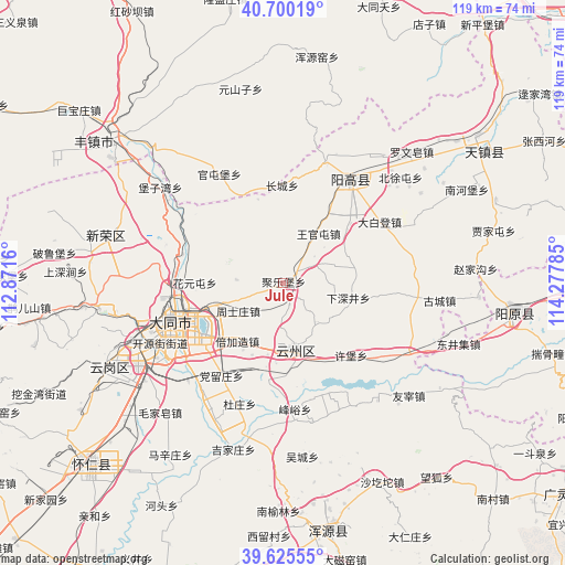
Jule GPS coordinates[2]
40° 9' 54" North, 113° 34' 28.992" East
| Map corner | latitude | longitude |
|---|---|---|
| Upper-left | 40.70019°, | 112.8716° |
| Center: | 40.165°, | 113.57472° |
| Lower-right: | 39.62555°, | 114.27785° |
| Map W x H: | 119.5×119.5 km | = 74.3×74.3mi |
| max Lat: | 53.31946° ⇑13% North |
| Jule: | 40.165° |
| min Lat: | ⇓87% South 18.22056° |
| min Long | Jule | max Long |
| 75.07348° | 113.57472° | 134.28917° |
| W 46.2%⇐ | ⇒53.8% E |
Elevation
Elevation of Jule is 1273 m = 4177 ft, and this is 788.2 m = 2586 ft above average elevation for this country.
| Max E: |
5622 m = 18445 ft | 10.9% |
| Jule | 1273 m 4177 ft | |
| Avg. | 484.8 m = 1591 ft | |
Min E: |
-3 m = -10 ft | 89.1% |
See also: China elevation on elevation.city.
Geographical zone
Jule is located in North temperate zone (between Tropic of Cancer and the Arctic Circle). Distance of this Northern Tropic circle is 1860 km =1155.8 mi to South.| Distance of | km | miles | from Jule |
|---|---|---|---|
| North Pole | 5541.1 | 3443.1 | to North |
| Arctic Circle | 2935.2 | 1823.8 | to North |
| Tropic Cancer | 1860 | 1155.8 | to South |
| Equator | 4465.9 | 2775 | to South |


Nearby cities:
15 places around Jule: (largest is in red/bold)
• Beijiazao
15.3 km =9.5 mi,  215°
215°
• Dangliuzhuang
23.5 km =14.6 mi,  213°
213°
• Datong
25.4 km =15.8 mi,  251°
251°
• Duzhuang
27.2 km =16.9 mi,  199°
199°
• Fengyu
26.8 km =16.7 mi,  174°
174°
• Guayuan
17.3 km =10.7 mi,  157°
157°
• Jijiazhuang
36.6 km =22.7 mi, 196°
• Longquan
23.4 km =14.5 mi,  19°
19°
• Majunying
30.9 km =19.2 mi, 254°
• Wucheng
37 km =23 mi, 173°
• Xihanling
33 km =20.5 mi,  239°
239°
• Xiping
14.2 km =8.8 mi, 169°
• Xubu
21 km =13 mi,  136°
136°
• Youzai
35.8 km =22.2 mi,  131°
131°
• Zhoushizhuang
10.8 km =6.7 mi, 238°
Sources, notices
• [Note1] Compared only with cities in China existing in our database
• [Src1] Map data: © OpenStreetMap contributors (CC-BY-SA)
• [Src2] Other city data from geonames.org with taken over terms of usage.
• [Src3] Geographical zone / Annual Mean Temperature by Robert A. Rohde @ Wikipedia
