Youzai geodata
Youzai (Shanxi) is a seat of a fourth-order administrative division; located in China in Asia/Shanghai (GMT+8) time zone. In our database, there are 1268 cities with bigger population. Compared to other cities in China, 86.2% of cities are located further ↓South; 52.1% of cities are located further →East and 84.6% of cities have lower elevation than Youzai. Note1


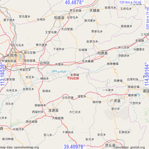
Youzai GPS coordinates[2]
39° 57' 3.276" North, 113° 53' 18.636" East
| Map corner | latitude | longitude |
|---|---|---|
| Upper-left | 40.4878°, | 113.18539° |
| Center: | 39.95091°, | 113.88851° |
| Lower-right: | 39.40978°, | 114.59164° |
| Map W x H: | 119.9×119.9 km | = 74.5×74.5mi |
| max Lat: | 53.31946° ⇑13.8% North |
| Youzai: | 39.95091° |
| min Lat: | ⇓86.2% South 18.22056° |
| min Long | Youzai | max Long |
| 75.07348° | 113.88851° | 134.28917° |
| W 47.9%⇐ | ⇒52.1% E |
Elevation
Elevation of Youzai is 958 m = 3143 ft, and this is 473.2 m = 1552 ft above average elevation for this country.
| Max E: |
5622 m = 18445 ft | 15.4% |
| Youzai | 958 m 3143 ft | |
| Avg. | 484.8 m = 1591 ft | |
Min E: |
-3 m = -10 ft | 84.6% |
See also: China elevation on elevation.city.
Geographical zone
Youzai is located in North temperate zone (between Tropic of Cancer and the Arctic Circle). Distance of this Northern Tropic circle is 1836.2 km =1141 mi to South.| Distance of | km | miles | from Youzai |
|---|---|---|---|
| North Pole | 5564.9 | 3457.9 | to North |
| Arctic Circle | 2959 | 1838.6 | to North |
| Tropic Cancer | 1836.2 | 1141 | to South |
| Equator | 4442.1 | 2760.2 | to South |


Nearby cities:
15 places around Youzai: (largest is in red/bold)
• Aoshi
6.8 km =4.2 mi,  75°
75°
• Caicun
30.8 km =19.1 mi,  221°
221°
• Darenzhuang
29.7 km =18.5 mi,  179°
179°
• Fengyu
24.3 km =15.1 mi,  263°
263°
• Guayuan
21.6 km =13.4 mi,  291°
291°
• Huanghuatan
33.3 km =20.7 mi,  186°
186°
• Huquan
30.5 km =19 mi,  124°
124°
• Jule
35.8 km =22.2 mi,  311°
311°
• Wanghu
18.3 km =11.4 mi,  161°
161°
• Wucheng
26 km =16.2 mi,  240°
240°
• Xiahan
34.4 km =21.4 mi, 222°
• Xicheng
29.1 km =18.1 mi,  52°
52°
• Xiping
26.1 km =16.2 mi, 292°
• Xubu
14.9 km =9.3 mi,  304°
304°
• Yong’an
33.2 km =20.6 mi,  211°
211°
Sources, notices
• [Note1] Compared only with cities in China existing in our database
• [Src1] Map data: © OpenStreetMap contributors (CC-BY-SA)
• [Src2] Other city data from geonames.org with taken over terms of usage.
• [Src3] Geographical zone / Annual Mean Temperature by Robert A. Rohde @ Wikipedia
