Jingxing geodata
Jingxing (Heilongjiang) is a seat of a fourth-order administrative division; located in China in Asia/Shanghai (GMT+8) time zone. In our database, there are 1268 cities with bigger population. Compared to other cities in China, 97.1% of cities are located further ↓South; 92.7% of cities are located further ←West and 50.8% of cities have lower elevation than Jingxing. Note1


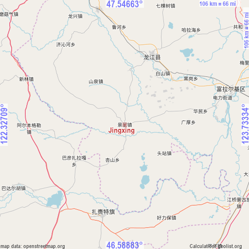
Jingxing GPS coordinates[2]
47° 4' 11.568" North, 123° 1' 48.756" East
| Map corner | latitude | longitude |
|---|---|---|
| Upper-left | 47.54663°, | 122.32709° |
| Center: | 47.06988°, | 123.03021° |
| Lower-right: | 46.58883°, | 123.73334° |
| Map W x H: | 106.5×106.5 km | = 66.2×66.2mi |
| max Lat: | 53.31946° ⇑2.9% North |
| Jingxing: | 47.06988° |
| min Lat: | ⇓97.1% South 18.22056° |
| min Long | Jingxing | max Long |
| 75.07348° | 123.03021° | 134.28917° |
| W 92.7%⇐ | ⇒7.3% E |
Elevation
Elevation of Jingxing is 172 m = 564 ft, and this is 312.8 m = 1026 ft below average elevation for this country.
| Max E: |
5622 m = 18445 ft | 49.2% |
| Avg. | 484.8 m = 1591 ft | |
| Jingxing | 172 m = 564 ft | |
Min E: |
-3 m = -10 ft | 50.8% |
See also: China elevation on elevation.city.
Geographical zone
Jingxing is located in North temperate zone (between Tropic of Cancer and the Arctic Circle). Distance of this North polar circle is 2167.5 km =1346.8 mi to North.| Distance of | km | miles | from Jingxing |
|---|---|---|---|
| North Pole | 4773.4 | 2966.1 | to North |
| Arctic Circle | 2167.5 | 1346.8 | to North |
| Tropic Cancer | 2627.8 | 1632.8 | to South |
| Equator | 5233.7 | 3252.1 | to South |


Nearby cities:
15 places around Jingxing: (largest is in red/bold)
• Baishan
27.3 km =17 mi,  36°
36°
• Changqing
46.3 km =28.8 mi,  68°
68°
• Duibao
23.4 km =14.5 mi,  5°
5°
• Du’ermenqin
39.5 km =24.5 mi,  78°
78°
• Guanghou
27.2 km =16.9 mi,  87°
87°
• Haolibao
43.6 km =27.1 mi,  155°
155°
• Heigang
34.2 km =21.3 mi,  54°
54°
• Heshan
31.6 km =19.6 mi, 11°
• Hong’an
47.5 km =29.5 mi, 71°
• Huamin
32.6 km =20.3 mi, 79°
• Hulan Ergi
48 km =29.8 mi, 71°
• Inder
41.8 km =26 mi,  190°
190°
• Longjiang
31.1 km =19.3 mi,  21°
21°
• Touzhan
20.8 km =12.9 mi,  125°
125°
• Yongfa
9.5 km =5.9 mi, 5°
Sources, notices
• [Note1] Compared only with cities in China existing in our database
• [Src1] Map data: © OpenStreetMap contributors (CC-BY-SA)
• [Src2] Other city data from geonames.org with taken over terms of usage.
• [Src3] Geographical zone / Annual Mean Temperature by Robert A. Rohde @ Wikipedia
