Yongfa geodata
Yongfa (Heilongjiang) is a seat of a fourth-order administrative division; located in China in Asia/Shanghai (GMT+8) time zone. In our database, there are 1268 cities with bigger population. Compared to other cities in China, 97.2% of cities are located further ↓South; 92.7% of cities are located further ←West and 51.3% of cities have lower elevation than Yongfa. Note1


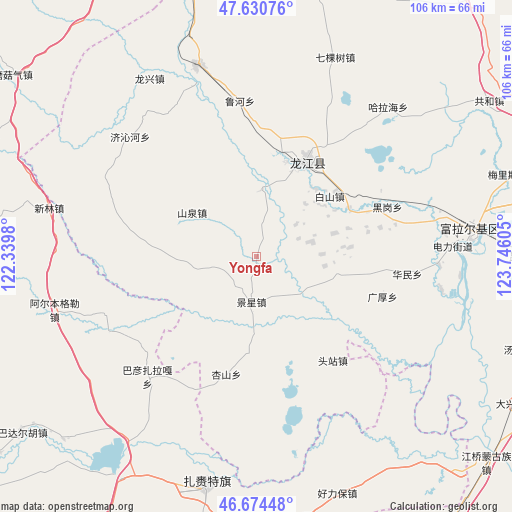
Yongfa GPS coordinates[2]
47° 9' 17.172" North, 123° 2' 34.512" East
| Map corner | latitude | longitude |
|---|---|---|
| Upper-left | 47.63076°, | 122.3398° |
| Center: | 47.15477°, | 123.04292° |
| Lower-right: | 46.67448°, | 123.74605° |
| Map W x H: | 106.3×106.3 km | = 66.1×66.1mi |
| max Lat: | 53.31946° ⇑2.8% North |
| Yongfa: | 47.15477° |
| min Lat: | ⇓97.2% South 18.22056° |
| min Long | Yongfa | max Long |
| 75.07348° | 123.04292° | 134.28917° |
| W 92.7%⇐ | ⇒7.3% E |
Elevation
Elevation of Yongfa is 175 m = 574 ft, and this is 309.8 m = 1016 ft below average elevation for this country.
| Max E: |
5622 m = 18445 ft | 48.7% |
| Avg. | 484.8 m = 1591 ft | |
| Yongfa | 175 m = 574 ft | |
Min E: |
-3 m = -10 ft | 51.3% |
See also: China elevation on elevation.city.
Geographical zone
Yongfa is located in North temperate zone (between Tropic of Cancer and the Arctic Circle). Distance of this North polar circle is 2158.1 km =1341 mi to North.| Distance of | km | miles | from Yongfa |
|---|---|---|---|
| North Pole | 4763.9 | 2960.1 | to North |
| Arctic Circle | 2158.1 | 1341 | to North |
| Tropic Cancer | 2637.2 | 1638.7 | to South |
| Equator | 5243.1 | 3257.9 | to South |


Nearby cities:
15 places around Yongfa: (largest is in red/bold)
• Baishan
19.7 km =12.2 mi,  50°
50°
• Changqing
42.8 km =26.6 mi,  80°
80°
• Duibao
13.9 km =8.6 mi,  4°
4°
• Du’ermenqin
37.8 km =23.5 mi,  92°
92°
• Guanghou
27.4 km =17 mi,  107°
107°
• Halahai
40.8 km =25.4 mi,  41°
41°
• Heigang
28.8 km =17.9 mi,  68°
68°
• Heshan
22.2 km =13.8 mi,  14°
14°
• Hong’an
44.4 km =27.6 mi, 82°
• Huamin
31.2 km =19.4 mi,  96°
96°
• Jingxing
9.5 km =5.9 mi,  185°
185°
• Longjiang
22.1 km =13.7 mi,  27°
27°
• Nianzishan
42 km =26.1 mi,  343°
343°
• Qikeshu
44.3 km =27.5 mi,  21°
21°
• Touzhan
26.9 km =16.7 mi,  143°
143°
Sources, notices
• [Note1] Compared only with cities in China existing in our database
• [Src1] Map data: © OpenStreetMap contributors (CC-BY-SA)
• [Src2] Other city data from geonames.org with taken over terms of usage.
• [Src3] Geographical zone / Annual Mean Temperature by Robert A. Rohde @ Wikipedia
