Huoshishan geodata
Huoshishan (Heilongjiang) is a seat of a fourth-order administrative division; located in China in Asia/Shanghai (GMT+8) time zone. In our database, there are 1268 cities with bigger population. Compared to other cities in China, 95.9% of cities are located further ↓South; 95.2% of cities are located further ←West and 51.9% of cities have lower elevation than Huoshishan. Note1


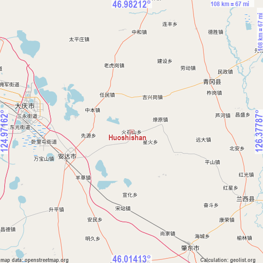
Huoshishan GPS coordinates[2]
46° 30' 1.008" North, 125° 40' 29.064" East
| Map corner | latitude | longitude |
|---|---|---|
| Upper-left | 46.98212°, | 124.97162° |
| Center: | 46.50028°, | 125.67474° |
| Lower-right: | 46.01413°, | 126.37787° |
| Map W x H: | 107.6×107.6 km | = 66.9×66.9mi |
| max Lat: | 53.31946° ⇑4.1% North |
| Huoshishan: | 46.50028° |
| min Lat: | ⇓95.9% South 18.22056° |
| min Long | Huoshishan | max Long |
| 75.07348° | 125.67474° | 134.28917° |
| W 95.2%⇐ | ⇒4.8% E |
Elevation
Elevation of Huoshishan is 180 m = 591 ft, and this is 304.8 m = 1000 ft below average elevation for this country.
| Max E: |
5622 m = 18445 ft | 48.1% |
| Avg. | 484.8 m = 1591 ft | |
| Huoshishan | 180 m = 591 ft | |
Min E: |
-3 m = -10 ft | 51.9% |
See also: China elevation on elevation.city.
Geographical zone
Huoshishan is located in North temperate zone (between Tropic of Cancer and the Arctic Circle). Distance of this North polar circle is 2230.8 km =1386.2 mi to North.| Distance of | km | miles | from Huoshishan |
|---|---|---|---|
| North Pole | 4836.7 | 3005.4 | to North |
| Arctic Circle | 2230.8 | 1386.2 | to North |
| Tropic Cancer | 2564.4 | 1593.4 | to South |
| Equator | 5170.3 | 3212.7 | to South |


Nearby cities:
15 places around Huoshishan: (largest is in red/bold)
• Anda
29.7 km =18.5 mi,  248°
248°
• Jianshe
31.7 km =19.7 mi,  24°
24°
• Jixinggang
16.5 km =10.3 mi,  31°
31°
• Laohugang
28.1 km =17.5 mi,  345°
345°
• Liaoyuan
12.7 km =7.9 mi,  67°
67°
• Qingkenpao
20.6 km =12.8 mi,  240°
240°
• Renmin
18.1 km =11.2 mi,  325°
325°
• Songzhan
31.2 km =19.4 mi,  186°
186°
• Wolitun
29.9 km =18.6 mi,  263°
263°
• Xianyuan
17.6 km =10.9 mi,  265°
265°
• Xinghuo
8.4 km =5.2 mi,  118°
118°
• Xuanhua
25.7 km =16 mi,  181°
181°
• Yangcao
27.3 km =17 mi,  226°
226°
• Yuanda
29.1 km =18.1 mi,  96°
96°
• Zhongben
18.3 km =11.4 mi,  299°
299°
Sources, notices
• [Note1] Compared only with cities in China existing in our database
• [Src1] Map data: © OpenStreetMap contributors (CC-BY-SA)
• [Src2] Other city data from geonames.org with taken over terms of usage.
• [Src3] Geographical zone / Annual Mean Temperature by Robert A. Rohde @ Wikipedia
