Gonghe geodata
Gonghe (Heilongjiang) is a seat of a fourth-order administrative division; located in China in Asia/Shanghai (GMT+8) time zone. In our database, there are 1268 cities with bigger population. Compared to other cities in China, 92.9% of cities are located further ↓South; 99.2% of cities are located further ←West and 73.1% of cities have lower elevation than Gonghe. Note1


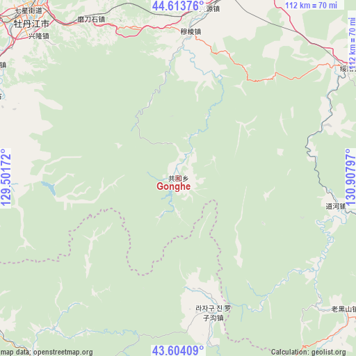
Gonghe GPS coordinates[2]
44° 6' 39.888" North, 130° 12' 17.424" East
| Map corner | latitude | longitude |
|---|---|---|
| Upper-left | 44.61376°, | 129.50172° |
| Center: | 44.11108°, | 130.20484° |
| Lower-right: | 43.60409°, | 130.90797° |
| Map W x H: | 112.3×112.3 km | = 69.8×69.8mi |
| max Lat: | 53.31946° ⇑7.1% North |
| Gonghe: | 44.11108° |
| min Lat: | ⇓92.9% South 18.22056° |
| min Long | Gonghe | max Long |
| 75.07348° | 130.20484° | 134.28917° |
| W 99.2%⇐ | ⇒0.8% E |
Elevation
Elevation of Gonghe is 478 m = 1568 ft, and this is 6.8 m = 22 ft below average elevation for this country.
| Max E: |
5622 m = 18445 ft | 26.9% |
| Avg. | 484.8 m = 1591 ft | |
| Gonghe | 478 m = 1568 ft | |
Min E: |
-3 m = -10 ft | 73.1% |
See also: China elevation on elevation.city.
Geographical zone
Gonghe is located in North temperate zone (between Tropic of Cancer and the Arctic Circle). Distance of this Northern Tropic circle is 2298.8 km =1428.4 mi to South.| Distance of | km | miles | from Gonghe |
|---|---|---|---|
| North Pole | 5102.4 | 3170.5 | to North |
| Arctic Circle | 2496.5 | 1551.3 | to North |
| Tropic Cancer | 2298.8 | 1428.4 | to South |
| Equator | 4904.7 | 3047.6 | to South |


Nearby cities:
15 places around Gonghe: (largest is in red/bold)
• Daohe
50.6 km =31.4 mi,  99°
99°
• Fanjia
65.7 km =40.8 mi,  296°
296°
• Langang
65.8 km =40.9 mi,  284°
284°
• Luozigou
43.8 km =27.2 mi,  165°
165°
• Maqiaohe
69.6 km =43.2 mi,  22°
22°
• Modaoshi
57 km =35.4 mi,  331°
331°
• Muleng
45.6 km =28.3 mi,  4°
4°
• Ning’an
64.3 km =40 mi,  293°
293°
• Suiyang
64 km =39.8 mi,  57°
57°
• Tieling
67.9 km =42.2 mi,  321°
321°
• Wenchun
67.3 km =41.8 mi, 301°
• Wolong
64.1 km =39.8 mi, 275°
• Xiachengzi
66.9 km =41.6 mi, 17°
• Xinglong
67.7 km =42.1 mi,  314°
314°
• Xingyuan
54.4 km =33.8 mi,  10°
10°
Sources, notices
• [Note1] Compared only with cities in China existing in our database
• [Src1] Map data: © OpenStreetMap contributors (CC-BY-SA)
• [Src2] Other city data from geonames.org with taken over terms of usage.
• [Src3] Geographical zone / Annual Mean Temperature by Robert A. Rohde @ Wikipedia
