Luozigou geodata
Luozigou (Jilin) is a seat of a fourth-order administrative division; located in China in Asia/Shanghai (GMT+8) time zone. In our database, there are 1268 cities with bigger population. Compared to other cities in China, 92.5% of cities are located further ↓South; 99.4% of cities are located further ←West and 68.2% of cities have lower elevation than Luozigou. Note1


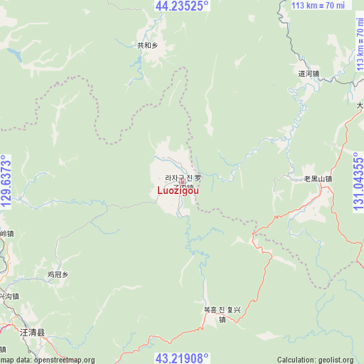
Luozigou GPS coordinates[2]
43° 43' 45.552" North, 130° 20' 25.512" East
| Map corner | latitude | longitude |
|---|---|---|
| Upper-left | 44.23525°, | 129.6373° |
| Center: | 43.72932°, | 130.34042° |
| Lower-right: | 43.21908°, | 131.04355° |
| Map W x H: | 113×113 km | = 70.2×70.2mi |
| max Lat: | 53.31946° ⇑7.5% North |
| Luozigou: | 43.72932° |
| min Lat: | ⇓92.5% South 18.22056° |
| min Long | Luozigou | max Long |
| 75.07348° | 130.34042° | 134.28917° |
| W 99.4%⇐ | ⇒0.59999999999999% E |
Elevation
Elevation of Luozigou is 380 m = 1247 ft, and this is 104.8 m = 344 ft below average elevation for this country.
| Max E: |
5622 m = 18445 ft | 31.8% |
| Avg. | 484.8 m = 1591 ft | |
| Luozigou | 380 m = 1247 ft | |
Min E: |
-3 m = -10 ft | 68.2% |
See also: China elevation on elevation.city.
Geographical zone
Luozigou is located in North temperate zone (between Tropic of Cancer and the Arctic Circle). Distance of this Northern Tropic circle is 2256.3 km =1402 mi to South.| Distance of | km | miles | from Luozigou |
|---|---|---|---|
| North Pole | 5144.8 | 3196.8 | to North |
| Arctic Circle | 2538.9 | 1577.6 | to North |
| Tropic Cancer | 2256.3 | 1402 | to South |
| Equator | 4862.2 | 3021.2 | to South |


Nearby cities:
15 places around Luozigou: (largest is in red/bold)
• Baicaogou
78.7 km =48.9 mi,  229°
229°
• Chunyang
73 km =45.4 mi,  268°
268°
• Daduchuan
63.1 km =39.2 mi,  67°
67°
• Daohe
51.7 km =32.1 mi,  49°
49°
• Daxinggou
65.4 km =40.6 mi,  236°
236°
• Dongguang
65 km =40.4 mi,  221°
221°
• Dongning
72.7 km =45.2 mi,  59°
59°
• Gonghe
43.8 km =27.2 mi,  345°
345°
• Hamatang
75.8 km =47.1 mi, 243°
• Jiguan
47.9 km =29.8 mi, 233°
• Jincang
42.2 km =26.2 mi,  164°
164°
• Laoheishan
43.4 km =27 mi,  92°
92°
• Sanchakou Chaoxianzu
78.6 km =48.8 mi, 65°
• Tianqiaoling
59.2 km =36.8 mi,  254°
254°
• Wangqing
64.9 km =40.3 mi, 225°
Sources, notices
• [Note1] Compared only with cities in China existing in our database
• [Src1] Map data: © OpenStreetMap contributors (CC-BY-SA)
• [Src2] Other city data from geonames.org with taken over terms of usage.
• [Src3] Geographical zone / Annual Mean Temperature by Robert A. Rohde @ Wikipedia
